
Alaska - The Last Frontier
- dougsmith51
- Sep 12, 2021
- 8 min read
Updated: Mar 27, 2022

The Last Frontier – at least that’s what the Alaska license plates say. It reminded us that the Alaska portion of our trip was nearing its end.
We'd already traveled most of the roads of Alaska. Interestingly, Alaska does not have that many roads, considering its size. You can see in the picture below they are concentrated in the southeastern corner of the state.

After our flying and glacier hiking adventures in Wrangell-St. Elias National Park, we headed north to Fairbanks on the Richardson Highway. On the way, we camped overnight in the Tangle Lakes area, with sweeping views of tundra landscape. We had hoped to explore it further, but Jeannette had come down with a cold, so we only stayed overnight and headed to Fairbanks the next morning.
The next two days were quiet ones, with Jeannette resting until her cold symptoms were on the decline.
When she was feeling better we ventured out to Creamer’s Dairy, which had been a working dairy farm for several decades.

The wetlands on the farm had always been a stopping place for migrating waterfowl. When the business closed in the 80s, the farm was sold to the state to preserve the wetlands so it could be a wildlife refuge. While we saw a number of Canadian geese, the largest population was of sandhill cranes. They have a very distinctive sound, a combination of honking and clicking. They also have a distinct flying profile with their long legs splayed out behind them. As they land, their legs move to support the landing which makes their last few moments of flight very wobbly and their landings quite clumsy. We hiked some of the trails in the refuge and enjoyed seeing the cranes coming in for those wobbly landings. We did note, however, they are very graceful when just walking through the tall grass.

Later that day, we visited a section of the Alaska oil pipeline. We had seen the pipeline from time to time coming north from Valdez to Fairbanks, as it parallels the Richardson Highway through eastern Alaska. This particular section had a display on the pipeline’s history, route, and technology.
The temperature of the oil coming through the pipeline is over 100 degrees, so to protect the permafrost much of that pipeline is elevated above ground. Cooling vanes in the supports allow the heat to disperse rather than going down into the supports.

To prevent breaks in case of earthquakes and to allow the pipeline to expand and contract due to weather, the pipeline is not bolted to the supports, but rather sits on sleds that can move laterally on the supports.

There was an exhibit on the “pigs” that travel through the pipeline to monitor conditions and keep the inner pipeline walls clean.

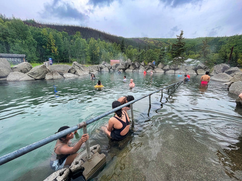
The next day, we drove about an hour northeast of Fairbanks to the Chena Hot Springs resort, soaking in an outdoor pool filled with water from the springs. A nice treat since the weather had been getting colder as we approached the end of August.


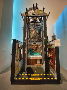
The day after, we visited the Museum of the North on the campus of the University of Alaska. It’s a beautiful, modern building sitting on a hill that overlooks all of Fairbanks.

The museum had a broad range of exhibits on animals, Alaskan history, and native and modern art by Alaska artists.


There was a 6,000-year-old mummified steppe bison called “Blue Babe.”

There was also a skeleton of a bow whale (bigger than a humpback) hanging in the entrance hall.

We learned that the museum will be the permanent home of the bus that featured in the movie “Into the Wild.”

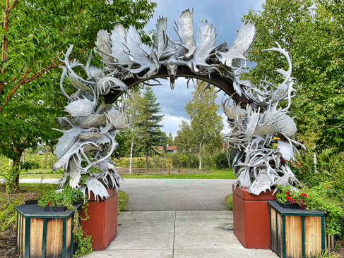
The next day we visited the Morris Thompson Cultural and Visitor Center, which had very interesting exhibits on the history and culture of “interior Alaska,” the area between the Alaska and Brooks Mountain ranges that includes Fairbanks. In addition to the exhibits, they also had a terrific antler arch outside.


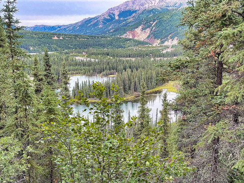
Back in the spring, we’d made a set of additional reservations at Denali National Park for August “just in case,” and decided to make a farewell visit to Denali, which is just a two-hour drive south from Fairbanks. We stayed at the Riley Creek Campground in the park, near the entrance. We arrived early enough to do a couple of day hikes our first day. The first was to Horseshoe Lake (named for its shape). We saw some impressive beaver dams and much evidence of their timbering prowess with trees up to foot in diameter being felled.


In the distance, we could see the hotels, restaurants, and stores that take care of the masses visiting the park.

For our second hike of the day, we took the Savage River Trail (which we’d hiked in early July, but in the opposite direction). The trail goes down one side and then up the other of the narrow, swift-flowing river.


The rocks are quite craggy and are some of the oldest exposed rock faces in North America.

As we neared the bridge that would allow us to cross the river for our return, we saw a couple taking wedding photos. Quite impressive since the bride was wearing a sleeveless dress and the temperatures were in the low 50s at best and the wind was blowing strongly.

The following day, we took our final bus trip into Denali NP, an eight-hour round trip to the Eielson Visitor Center.

It was cloudy, so we were not able to see The Mountain. However, recent storms had left some of the peaks sprinkled with snow, which lent a different feel from our trips seven weeks before.


The tundra ground cover was also beginning to show its fall colors.

We also had great wildlife sightings, including a moose, some Dall Sheep on a mountainside, and a whole herd of caribou migrating together on a hillside. Soon there would be many more caribou on their annual migration to the park from points north.


The highlight of the trip was a grizzly bear that walked onto the road right in front of the bus, and continued walking (oblivious to us, it seemed) for more than five minutes. As it lumbered along, you could see the powerful muscles in its neck and legs.

Eventually, it caught a ground squirrel and took it to the side of the road for an afternoon snack. The bus was able to come up alongside, allowing for some great photo opportunities.


The next morning we returned to Fairbanks to prepare for our departure from Alaska. We replenished our supplies in Fairbanks, stopping at a Alaskan food chain called Fred Meyers which offers a one stop shopping experience combining groceries, clothing, and general supply store.
It was time to begin our trip south. We first drove to the town of Delta Junction, which serves as the northern terminus of the Alaska Highway. The Canadian border had opened to American tourists on August 9, but they were still being cautious. In addition to requiring full vaccination, they also made you bring the results of a negative COVID test taken within the previous 72 yours. We had made appointments for the tests at a health clinic in Delta Junction (about a third of the cost of getting tested in Fairbanks), and were able to get our results (negative, thank goodness) within 30 minutes of our arrival.
We topped off the gas tank before getting on to the Alaska Highway, since gas stations are few and far between, and headed toward the Canadian Border. The Alaska Highway is 1,365 miles long and we hoped to complete it in 5 or 6 days of long driving. The first portion of the route south is in the worst shape, so we did not reach the border that first night. We had to take it relatively slow to deal with the frost heaves, potholes, and changes from paved highway to gravel and back again. To protect the Fittata, we put up a shield we’d been carrying in the basement of the RV. We also wrapped the windshield and front of the car with an anti-collision film to protect it from flying rocks. We kept the Fittata attached to the Ciaowagen for the next five days, and our precautions definitely helped. At the end the Fittata was covered in mud and dirt (it rained for about half of our drive) but was otherwise undamaged!
We boondocked in a road pullout about 20 miles from the border the first night. The next morning, we drove to the border crossing. There was only one vehicle in front of us, and when our turn came, we were cleared to go in about 3 minutes. Whew! We changed from Alaska Time to Mountain Standard Time as we crossed into the Yukon, losing an hour.
We drove all day, reaching the Yukon town of Whitehorse where we stayed in an RV park. The bad sections of road had ended about halfway between the border and Whitehorse, so it was smooth sailing from then on. Some of the Alaska Highway went through beautiful mountain country, other parts went through flat plains. We did not take photos along the way as we were intent on our driving.
Along our route we would see wildlife either on or beside of the road, such as these bison and Stone Sheep.


Departing Whitehorse, we made it the next day to the town of Watson Lake. There we toured their famous “signpost forest,” which started during WW II as the Alaska Highway was being built, when a homesick road worker put up a sign from his hometown. It now contains thousands of signs left by people who have passed through and the town keeps adding more posts each year to make sure there is room for ever more signs.

We stayed the night in an RV park behind a Watson Lake roadhouse. The night was clear, and when Doug stepped outside, he though he saw some faint auroras in the sky. He asked Jeannette to join him, and we were soon treated to a full-blown display of the aurora borealis! We’d seen auroras a few times in the past, but this was by far the best, with waving curtains on the horizon, then moving directly above our heads, then dimming, then lighting up again. Doug was able to get some photos using Night Mode on his iPhone.


We headed east and then south from Watson Lake, crossing from the Yukon to British Columbia and changing to Pacific Daylight Time (which matches Mountain Standard Time during the summer). That day, we stopped at Liard Hot Springs Provincial Park, pretty much a mandatory stop for anyone traveling the Alaska Highway. A half-mile walk along a boardwalk brings you to a changing area and quite delightful hot springs.

The hottest areas are where the springs bubble up at one end, and then cool as you move downstream. You just pick the area with the temperature that suits you, and settle in. Although the springs are all natural, BC Parks has lined the bottom with gravel so it’s comfortable to stand and move around. We thought these springs were much nicer than the Chena Hot Springs we’d visited a few days earlier.

We spent the rest of that day and another day driving to Dawson Creek, BC, overnighting at the Toad River Lodge RV Park, an outpost that provided the only accommodations, gas, and food for at least 75 miles in either direction.
Finally, we arrived at Dawson Creek, the town that marks the southern terminus of the Alaska Highway. A sign in town designates “Mile 0” (although for us, it was Mile 1,365). Even though we’d generally driven south from Alaska, Dawson Creek itself is still halfway up the length of British Columbia from the U.S. border, so there was still some significant driving ahead of us in future days.

We camped in Dawson Creek for two nights, unhooking the Fittata from the back of the RV for the first time since we’d left Fairbanks. We removed the windshield wrap, and drove it through a car wash. Finally, our car was blue again!
Dawson Creek was a town large enough to host a Walmart (albeit a small one) so we were able to replenish some supplies.
Our next goal was to spend a week exploring Jasper and Banff National Parks in Alberta, but you’ll have to read about that one in our next blog post!


Doug, I've said this before but I'll repeat it: REALLY enjoying the descriptions and pictures. I know it takes a goodly amount of time to put all this together on the fly and I thank you for doing so. It's a wonderful life! Monty Allen 😎