
Basin and Island
- dougsmith51
- Sep 17, 2020
- 3 min read
We left Idaho after spending the month of August there, and first traveled south into Nevada. Nevada is a state with wide open spaces - you can go for 30-50 miles between towns, especially in the eastern part of the state where we were. We settled into an RV park in the SMALL town of Baker (population 68) and visited Great Basin National Park, another one of those national parks that few people have heard of. It gets fewer than 100,000 visitors per year.
They call the northern half of Nevada the Great Basin because it does not have any natural water outlets like rivers. Rain that falls either evaporates or drips down into the aquifer. Great Basin NP was created to preserve some of that ecology.

While much of it is wilderness, there is a scenic drive that climbs Mount Wheeler up to 10,000 feet altitude.

As you climb higher, you can see the vast expanse of the desert basin below.

You can also see Nevada's one and only glacier. The top is mostly covered with rock (which may be helping to preserve it), but ice peeks out the sides.

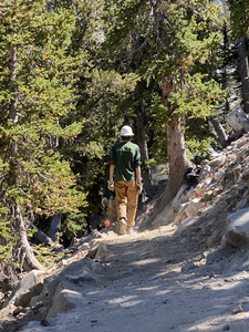
One day we parked at the end of the road, and hiked up another 500 feet to an ancient bristlecone forest.

Bristlecone pines are the oldest living things on earth - some are over 5,000 years old. The oldest trees in this grove were about 3,500 years old, which they've determined by taking small core samples and counting the rings.
Bristlecones survive on the edge of the hardest ecological niches. They prefer the windswept edges of cliffs right at the tree line. To survive over the centuries, they develop a very thick resin that makes their wood incredibly hard, protecting them from fire and helping them store water for times of drought. In really tough times, they will cut off resources to one section and redirect them to other younger parts of the tree so it can continue to grow. Their trunks are twisted into fantastic shapes by the wind. Their pine needles grow in groups of 5 and will live about 40 years.


When their cones first form, they are purple and dripping with sap, then turn brown and dry out as they mature.


On our hike, we ran into a group of young people from Americorps doing trail maintenance. They were glad to be able to work in the outdoors rather than doing data entry indoors.


On our second day in the park, we again drove up the scenic road, and this time we hiked through some beautiful pine and aspen forests to an alpine lake. The lake has no stream outlet, and had evaporated about half-away since the spring snow melts.


Leaving Nevada, we drove east into Utah, passing a large salt flat along the way.

We camped for two nights at Antelope Island State Park, which sits in the Great Salt Lake about 10 miles northwest of Salt Lake City. The island is 15 miles long and is attached to the mainland by a causeway. The Great Salt Lake has no natural outlet, so its size changes from year-to-year depending on rainfall, snow melt, and evaporation rates. This time of year, Antelope Island was more of a peninsula than an island.

The island is named after its herds of pronghorns (antelopes). They tend to be shy, but we did see some by the roadside.

They also have a herd of bison that have grown from a few that were brought to the island in 1893. The state has built a fence out in the lake flats to ensure the bison stay on the island.


We were treated to a spectacular sunset our first evening, with blood red skies reflected in the waters of the Great Salt Lake. We could also see Salt Lake City sitting in the distance below the Wasatch Mountains.


We did a bit of hiking on the island, including going up to Buffalo Point which provided great views of the lakeshore. We didn't see any bison there, but we did see some bison droppings on our way up.


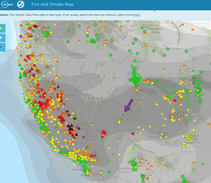
We had been watching the EPA's fire and smoke tracker (we were at the dot indicated by the purple arrow). On our second day, smoke from the West Coast wildfires blew back in - we could actually see he smoke descending lower and lower over the island's hills till it reached the ground.


Although the smoke trails were changing from day-to-day, we hoped to get to clearer skies again as we headed south. More about that in our next blog entry!


Comments