
Eau Canada!
- dougsmith51
- Aug 26, 2023
- 7 min read
Updated: Jun 2, 2024

After our side trip to the Black Hills, it was time to explore the Canadian side of the Great Lakes. Canada is much less populated than the U.S., so while the drive was beautiful there were fewer things to explore - our total time in Canada was only about two-and-a-half weeks.
The first week-and-a-half was spent driving around the north shore of Lake Superior. That was just fine with us, since in our opinion it's the prettiest and most dramatic of all the Great Lakes. Because of the lakes' configuration, we bypassed the north shorelines of Lake Michigan and Lake Erie during our Canadian travels. Also, our Canadian travel was entirely within Ontario, quite a sizeable province.
Our first Canadian stop was in the town of Thunder Bay, about 40 miles north of the border. It's a seaport with a population of about 100,000. The lake-side harbor featured huge silos, holding grains shipped by rail until the large cargo vessels come into port to be filled before turning around on their return journey. There wasn't much exciting to do in town, although we did get some shopping done and also went to see the new Mission Impossible movie.
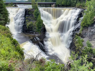
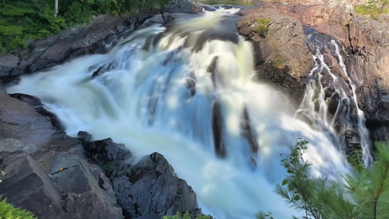
There were some nice natural areas to visit in the area, though. We visited Kakabeka Falls Provincial Park. The waterfall there is pretty, with significant water flow. Locals call it "the Niagara of the North." There were trails to view the falls from both shores.


On our way back to the campground, we stopped to see a statue of Canadian hero Terry Fox. He was a young man who developed cancer and lost a leg. In 1981, he started a cross-Canadian run, to raise money and increase cancer awareness, that captivated the nation. Sadly, his cancer recurred and he had to terminate his run near Thunder Bay. Each year, over 650 Canadian communities hold Terry Fox runs that have, to-date, raised over $750M for cancer research.

The next day we traveled to Sleeping Giant Provincial Park, a large park that occupies a whole peninsula sticking south into Lake Superior. We hiked the Sea Lion trail which leads to a stone arch by the shore. When first discovered, it had a shape like a crouching lion (hence the name) although parts have fallen off since, obliterating the likeness of a lion.

In the background of this photo from the park's Marie Louise Lake, you can see the mountain shapes which led to the area being called Sleeping Giant - the head and chest are to the right and the legs to the left. The mountain was originally named by First Nations people in the area.

The next day we packed up camp and drove to the town of Marathon, near the northernmost point of Lake Superior, settling in at a community campground. That evening, we took a hike around the town's Penn Lake.

While staying in Marathon, we visited Pukaskwa National Park about a half-hour south. The park is mostly wilderness and hosts a 120-kilometer kayak route along the Lake Superior shore. We hiked two connected trails at the north end of the park, the Southern Headland trail and the Manito Miikana trail, which climbed over granite cliffs and provided impressive views of the Lake Superior shoreline.


We discovered a set of the red Adirondack chairs Parks Canada has placed at scenic areas in national parks across the country.

Moving on, we traveled to Sault (pronounced "Soo") Ste Marie at the eastern end of Lake Superior. The area was named by early French missionaries. Along the way, we stopped for lunch at the town of Wawa, which sported a large statue of a Canadian Goose ("Wawa" is the Native American word for goose) and visited the pretty waterfall nearby called Magpie Falls.


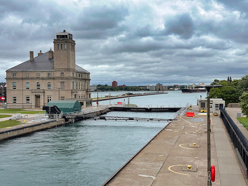
Sault Ste Marie is on the U.S. border and there are two towns with the same name, one in Ontario (where we were staying) and one in Michigan. Sault Ste Marie's claim to fame are its giant locks (the Soo Locks) which connect Lake Superior with St. Mary's River and ultimately Lake Huron, bypassing rapids which drop 21 feet. "Sault" means "rapid" in French.
We crossed over into the US for the day to see the Soo Locks in action. The locks, built and operated by the U.S. Army Corps of Engineers (COE), can accommodate freighters up to 1,000 feet in length carrying ore, grain, and other materials throughout the Great Lakes and out to the Atlantic. Ships do not have to pay any fees to use the locks. There are currently a smaller and larger lock, and a new large lock is under construction with completion slated for 2030.
The COE had an informative visitors center, where kids and adults could indulge their inner lock keeper.


The COE has also built a viewing platform where you can see the locks in action.


We watched a large freighter and two tour boats enter the locks from the downstream side. The lock gates were closed, and the locks filled with over 20 million gallons of water from the upstream side, raising the vessels. When the level was even with Lake Superior, the upper lock gates opened and the ships steamed out. The process takes a while, so we have captured it in timelapse below.
Multiple Canadian and US companies operate tour boats through the locks. Since we were on the Canadian side, the next day we chose to cruise with Miss Marie Sault Locks Tours.

The tour boat started upstream and passed through historic locks now operated by Parks Canada. The locks are used mainly by tour boats and recreational craft.


We then steamed into Lake Superior and by a massive steel plant. The raw materials needed for steel - iron ore, limestone, and coal - all come from quarries on the Great Lakes and are delivered to the site via the massive lake freighters. We saw the same large ship we'd seen the previous day going through the Soo Locks offloading some of its cargo.


We then passed underneath the international bridge and through the American Soo Locks before returning to the Canadian dock.
After the cruise, we walked along the waterfront and visited the Canadian historical locks park.


We continued east. We stayed overnight in Chutes Provincial Park. It contains a waterfall and some cascades.


We found out how the park got its name. In the 1800s, loggers floating their logs downriver to market sometimes had to build wooden chutes (see picture below) to bypass rapids and waterfalls.

We hiked a park trail along the Spanish River and discovered some Adirondack chairs were we relaxed and took in the view.s


We moved on, traveling first east and then south near the Lake Huron shoreline to a campground in the town of Springwater. While there, we drove to the town of Collingswood and biked about 16 miles on the Georgian Trail, a rail trail along the Lake. We'd been hauling our two Lectric e-Bikes in the back of the Fittata since the beginning of our trip. Unfortunately, Jeannette had broken a rib shortly before we left on this summer's trip, and needed to give it time to heal before she could do any heavy lifting. This was our first chance to use the bikes on our travels this year.

We headed south from Springwater and drove through the outskirts of Toronto before turning east to trace the northern shore of Lake Ontario. This took us to the 1000 Islands area of the St. Lawrence River, and we stayed in a campground near the small village of Ivy Lea.
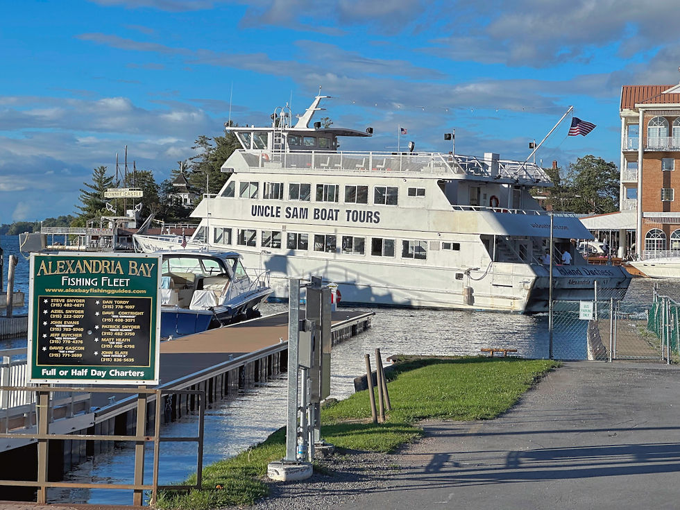
We took another day trip to the U.S. to the town of Alexandria Bay, where we boarded an Uncle Sam Bout Tour boat for a two-hour cruise among the islands.
We learned there are actually 1,864 islands in the 1000 Islands area of the river. To count as one of the 1000 Islands, an island must span at least one square foot, stay above water level year-round, and support at least one living tree or bush.

Many of the islands we passed had homes or other structures.


We passed beneath another international bridge.

We saw a statue of St. Lawrence himself. The patron saint of cooks, St. Lawrence was martyred in 258 AD, burned alive on a grate, when he turned over the growing riches of the Church to the poor and indigent rather than surrendering them to the Romans. The statue on the river holds a grate, memorializing the martyrdom.

As we neared the end of our voyage, we were dropped off on Heart Island where we visited the Boldt Castle.

The Castle was around the turn of the last century by George Boldt, proprietor of the Waldorf-Astoria hotel in NYC and the Bellevue-Stratford hotel in Philadelphia, as a gift for his beloved wife Louise. A number of buildings were constructed on the island. The main house (the Castle) was still under construction when Louise passed away suddenly.

Boldt ordered the work to be ceased and, it is said, never visited Heart Island again. The building lay abandoned for 73 years, falling into disrepair from nature and vandalism. The Thousand Islands Bridge Authority bought the Island in 1973 for $1, with a stipulation that any tour fees would be used to reconstruct the island and its buildings. Some $50M has been spent so far on the ongoing renovations. The first two floors of the six-story Castle have been restored and decorated according to the original plans, with period furnishings.

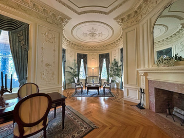


You can see the previous state of the Castle in the upper floors, with exposed walls and graffiti. Still the house is quite impressive to visit.


We also visited Alster Tower on the island, which contains a stage and two bowling alleys. That building is in the early stages of reconstruction.


We took a shuttle boat back to Alexandria Bay and then drove the Fittata back to our campground in Canada.
The next day we got on our bikes again and rode 16 miles on a bike trail alongside Thousand Islands Parkway. We were able to ride directly out of our campground onto the trail.
We also visited the town of Brockville, further east on the St. Lawrence River.


We visited the half-kilometer Brockville Railway Tunnel which runs under the town. No longer used, the town has equipped the tunnel with colored lights and music, making it a quite unique site to visit and to practice some creative photography.


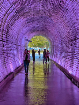

[Turn up your audio to in the video below to hear the music]


The next day, we drove further east on the St. Lawrence River and then crossed into the U.S. for good. More about that in our next blog post.


コメント