
Eastern Alaska
- dougsmith51
- Aug 20, 2021
- 9 min read
Updated: May 4, 2022

Much of the Alaskan tourist action takes place in the Fairbanks to Kenai Peninsula corridor. The eastern part of Alaska gets fewer visitors, but that's not because it's any less spectacular. That's where we headed next to continue our Alaska adventures. We had been traveling from Anchorage on the Glenn Highway, but turned south onto the Richardson Highway, the main north-south road for eastern Alaska.
Our first stop was Valdez. It's sometimes described as the "Switzerland of Alaska" because of its dramatic scenery. However, we couldn't confirm that personally because it rained nonstop during our visit there, and the clouds hung low, obscuring the mountains.
We'd told ourselves that we could use a rest from our nonstop activity, and Valdez did offer that. Doug was able to concentrate on getting some work done for his CFO client, and Jeannette worked on some RV fix-up projects and re-organizing.
Valdez was fairly crowded with fishermen because the pink salmon were running in the creeks. There are four varieties of salmon in Alaska, and they return to their birthplaces to spawn at different times of the year. We visited the Soloman Gulch Hatchery outside of town - they spawn and release hundreds of thousands of pink and coho salmon each year. And each year, salmon they released into the wild three or four years previously return to the hatchery when they are ready to release their eggs and fertilized them.

If you look closely at the video below, what looks like choppy water is actually thousands of salmon approaching the hatchery.
The local sea lions were taking full advantage of the concentration of fish.

Some salmon try to jump the falls and continue upstream.
However, this is what lies ahead of them (admittedly, the falls were exceptionally full due to all the rain).

Many salmon, however, make it into a series of artificial ladders leading into the hatchery. They must pass through about 10-15 gates to get to the end - the hatchery doesn't make it too easy for them. Swimming upstream and over obstacles is part of their natural behavior.
We were not allowed into the fishery building, but the video capture below shows what's going on. Salmon are lifted by a large scooping bucket (upper left screen) and dumped onto steel tables (right two screens) where workers sort them (perhaps by sex or some other characteristic - it wasn't clear to us). In the lower left hand part of the screen, you can see how workers slit the salmon open to get at the sperm and eggs which drip down ramps into buckets. It seems cruel, but the salmon die shortly after spawning naturally, so this just speeds up the natural process. These sperm and eggs are later combined to create new baby salmon, which are stored in special containers in the waters near the hatchery for a few weeks until they've grown to a size where they can be released into the wild. More salmon can make it to adulthood this way as they are kept safe from predators during this critical stage.

We were disappointed by the Valdez wash-out, but it was time to move on. On the way out of town, we stopped for a bit to admire the many waterfalls in Keystone Canyon that were running at full capacity.


Our next destination was the town of McCarthy, Alaska and the Kennicott Mines National Historic Landmark. These both lie in Wrangell-St. Elias National Park, which is the nation's largest national park (it's six times the size of Yellowstone). A quarter of the park is covered by glaciers, and it's also a hotbed of volcanic activity. It encompasses three mountain ranges. It's mostly wilderness. Although Wrangell-St. Elias NP is really big, we note that 7 of the 10 largest U.S. national parks are in Alaska.
The 62 mile road to McCarthy from the small town of Chitina is dirt and gravel, and fairly treacherous. We'd tried driving part of this road during our 1985 Alaska visit, but were stopped by this high rail road trestle over a raging river. At that time the surface of the bridge was wood planks overtop of the wooden RR ties, and it lacked a guardrail. The McCarthy road is listed on the website dangerousroads.org for good reason.

Nowadays the trestle serves as a one-lane bridge on the McCarthy road and has new wooden decking and guardrails.

During that trip in 1985, we only made it one-third of the way on the road, but still ended up with a flat tire. This visit, we decided we would let someone else do the driving (and take the driving risk). We left the Ciaowagen in an RV park in Chitina, and were picked up by a shuttle van to drive us to McCarthy. The shuttle van driver told us that they usually have to buy 50 tires each season for the vans that make 2 trips per day over the 60 miles of "road." The trip takes over 2 hours each way because of the road conditions.
The van stops at McCarthy Creek, where there is only a footbridge across the very wide creek (Jeannette asserts that it really should be called a raging river). After crossing the bridge, its another mile to the town of McCarthy.

On the far side, a couple of shuttle services transport visitors to local establishments and the nearby town of Kennicott.

McCarthy is currently a small town totally dependent on tourism. A hundred years ago McCarthy was the largest city in Alaska (more about that below). The town has a sort of Wild West vibe. Although the main street was a sea of mud during our visit, locals assured us that the roadway was actually dry for a couple of days each tourist season.

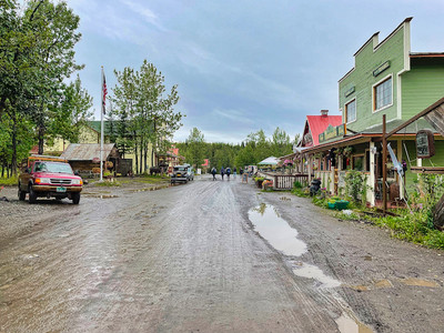


We stayed for two nights in Ma Johnson's Hotel, a historic landmark. It was cute (but expensive, with shared baths in the hallway). Breakfast was included at the Saloon across the street, and there was also a fine dining restaurant called the Salmon and Bear where we ate dinner our second night in town.

McCarthy's rise came from the discovery of one of the richest copper deposits in the world, which was mined in Kennicott from 1911-1938. JP Morgan and Daniel Guggenhiem bankrolled the enterprise and built a 196-mile railway with 44 f bridges, (many of which were wiped out and had to be rebuilt each spring) to get the ore shipped from one of Alaska's ports. The railroad cost $25M to build, but don't feel sorry for the investors. during the time the mine was active, they managed to ship 4 million tons of ore valued at $200M (in 1938 dollars). At its height, the whole operation employed about 700 people working round the clock 363 days a year. Kennicott was the business town for the mines, while McCarthy served as the "support town" for the mines (e.g., the yellow building to the right of the hotel was the town brothel). It also had a school, hospital, and library.
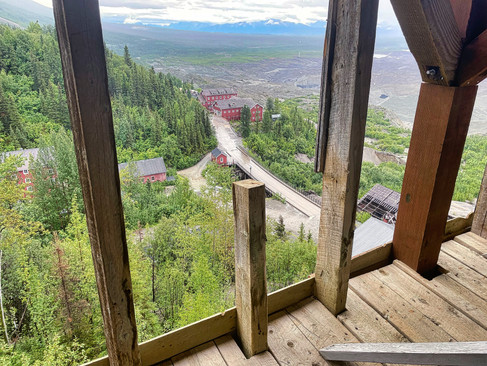
The afternoon of our arrival, we took the shuttle up to Kennicott (about 5 miles away). The mill and support buildings are run as a national historic landmark by the National Park Service.


The large red building built on the hillside is the mill. The mines themselves were about 3-4 miles uphill from the mill.
Running through the valley in front of the mill is the Kennicott Glacier. 100 years ago, it towered 200 feet above the town. Now, it has melted to a much lower height, and the top is covered with gravel left behind by the melting process. In this picture below, where the green ends, the glacier begins

There is a museum in town that talks about Kennicott's moment in the sun, and several of the town buildings such as the school, the mine office, and the general store have been restored.

In order to view inside the mill building, you have to be on a guided tour for safety reasons and wear hard hats. Tours are operated by St. Elias Alpine Guides, the park's concessionaire. We signed up for a 3:30 pm tour, which lasted about two hours.
When the mines ran out, the town emptied out almost immediately. The buildings were left as-is. Some of the equipment was looted in subsequent years, and some of the wood from the buildings was reused by locals (sort of like the Coliseum was partly disassembled after the fall of the Roman Empire). The NPS has worked in recent years to stabilize the buildings, but does not plan to restore the mill fully.
After a long hike up to the top level of the mill, visitors are guided along the path the copper rich ore took down through the building. The mill took in stone from the mines and processes of grinding, crushing, shaking, floating, and dissolving eventually released the copper from the stone.

Ore was carried down from the mines high above town in buckets that ran on miles of long cables, like a ski lift.

The upper floors of the mill contained various crushing machines (water or electricity-powered) that reduced the ore to smaller and smaller sizes. For particular rocks not crushed enough by the machines, men went at them with big steel hammers.

There were several floors used to crush the rocks, and we had to go down steep ladders between floors. With each floor, the crushed ore pieces were reduced in size.

As we continued down through the building, we could see views of the town on either side of us.


In the lower levels, shaking tables and water were used to separate the heavier copper-bearing rocks from the lighter limestone.

Finally at the bottom, chemical vats used ammonia to leach out the final traces of limestone from the ore.

On the ground floor of the mill, the ore was piled into rail cars and sent 200 miles to the port of Cordova. It was then put on ships to smelting operations in Tacoma, Washington.

We returned to McCarthy and ate dinner at one of the tasty restaurants in town, called The Potato.

It had been rainy and cloudy so far during our time in McCarthy, but the next morning the sun was out and we could see Mount Blackburn in the distance.

We signed up to do a hike on the Root Glacier, again led by St. Elias Alpine Guides. Leaving from the town of Kennicott, we first hiked about two miles to where the Root and Kennicott glaciers come together. Our group included four hikers and a guide.


In contrast to the "dirty" Kennicott, the Root looks like a proper glacier, with mostly white and blue ice. Flowing down seven miles through its valley, it starts with a 7,000 foot-high icefall, which is the third highest icefall in the world (the first two are in the Himalayas).

We hiked down to the toe of the glacier, put on crampons provided by the guide company, and started hiking up onto the glacier which started out as ice covered gravel but quickly turned to pure ice. The texture was much different than the Matanuska Glacier we'd hiked on the week before. Very few holes or crevasses. Instead, the surface rolled, reminding us of a skateboard park.


We hiked on the glacier for about an hour, and stopped for pictures and lunch.

One interesting sight were groups of moss that live on the ice. They are referred to as "glacier mice" as they can move around in ways that are not related to gravity, water flow, or wind. Scientists are busy try to figure out how they move and how they do so in a coordinated way with larger groups of other "mice".

Although the hike was fun, it was also challenging because of the small hills and ripples on the ice (as you can see in the photo below) which were difficult to see in the flat lighting and which forced you to balance carefully on your crampons. By the time we'd hiked off the glacier and back the two miles to Kennicott, we were pretty tired!

On the morning of our third and final day in McCarthy, we'd arranged to do a flightseeing tour of the area with Wrangell Mountain Air, taking off from a gravel airstrip near the town. The views and scenery were, to say the least, spectacular! Out of a couple hundred photos each of us took out the windows of the plane, here are some of the best.


We also saw beautiful waterfalls coming down sheer cliffs up to a mile high.


We also loved the contrast of white/blue glaciers and colorful cliffs caused by various mineral deposits and lichens growing on the rock.


As we neared the end of our flight, we flew over the Root Glacier. Looking down the valley toward the terminus, concentric arcs show the flow from year-to-year.

Our pilot also flew past the front of the icefall at the beginning of the Root Glacier (click on the video to see).
As we approached our landing, we were able to see the Kennicott Mill and the McCarthy River footbridge.


We returned to McCarthy, took the shuttle up to Kennicott, and ate a tasty lunch on the outside porch of the Kennicott Glacier Lodge.
Then it was back to McCarthy to pick up our bags, walk back across the footbridge, and catch the Kennicott Shuttle back to Chitina. Unlike our ride to McCarthy, when the van was packed, this time it was just the two of us and the driver.
We asked him how often he saw animals alongside the road when shuttling people, and he estimated 40% of the trips, mostly moose. We did not see any moose, but he did stop to move this tiny shrew, just a bit smaller than a tennis ball, from the middle of the road so it wouldn't be squashed by another vehicle.

As we neared the end of the road, we stopped for a view of the confluence of the Chitina and Copper Rivers.

The completion of our visit to Wrangell-St. Elias NP brought our Alaska national parks total to five. In combination with the five national parks we'd visited while traveling from Virginia to Washington, we are able to add 10 more vintage postcards to our Ciaowagen-Door-of-National-Parks-Visited poster, bringing our total to 44 parks visited in the last three years.

We stayed overnight in Chitina, used the next morning to wash some of the bugs and dust off the Ciaowagen, emptied our holding tanks, and headed north along the Richardson Highway toward Fairbanks. More about that in our next blog post.
Fascinating! I especially liked the copper tower description. My aunt was born in Fairbanks in 1924 as my grandfather was teaching metallurgy at the university in town. He was a copper assayist for his entire career, starting out in the mining towns in Nevada, Mexico, Arizona and eventually for ATT through the depression years...as they laid telephone lines.