
Glaciers and Earthquakes and Bears, Oh My!
- dougsmith51
- Aug 3, 2021
- 11 min read
Updated: Mar 27, 2022

Leaving the Denali area, we headed south to Anchorage. While Anchorage is the largest city in Alaska, TripAdvisor’s list of top-things-to-do are outside the city limits. So rather than exploring Anchorage, we used our time to catch up on some “life maintenance” needs. We spent a day replenishing our food supply, doing laundry, getting haircuts (Jeannette’s at a salon, and Doug’s cut courtesy of Jeannette), and having some minor RV repairs done.
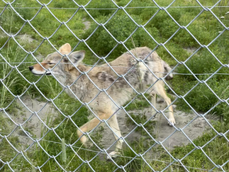
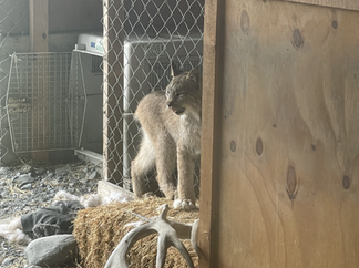
We ventured an hour south of the city to visit the Alaska Wildlife Conservation Center (AWCC), a nonprofit that operates a sort-of outdoor zoo featuring rescued wildlife. We were able to see wolves, black bears, grizzlies, moose, a lynx, a porcupine, caribou and reindeer (similar, but not the same thing), a coyote, and a bald eagle. The AWCC is particularly proud of their work reintroducing bison to Alaska (they were wiped out in the late 1800s) and they released their first animals into the wild a couple of years ago.


On the way to the AWCC, we drove along Turnagain Arm, a channel of Cook Inlet (which connects Anchorage to the Pacific). Turnagain Arm is famous for its twice daily “tidal bore” where the rising tide meets water flowing out of the Arm. In the right conditions, it causes a standing wave moving upstream at about 10 mph, and we were able to see people surfing that wave (see video below), billed as the longest surfing ride in the US.
The next day we headed out of town for an overnight trip to Glacier Bay National Park. There are no roads connecting Anchorage with the Glacier Bay area near Juneau, so we left the Ciaowagen at the campground in Anchorage and flew on Alaska Air to Juneau. Again, with no connecting roads available, we took an 18 min. flight to the small town of Gustavus, which serves as the gateway to the national park. We stayed at the Glacier Bay Lodge in Bartlett Cove, with a great view from our room to the expanse of the cove.

This area of Alaska gets precipitation 260 days a year, creating a lush rainforest. After dinner we hiked the Forest Loop trail near the lodge for a first-hand experience. Moss, lichen, and fungus grow on the trees and the forest floor. Some fallen trees and stumps served as “nurse trees,” with new trees growing on them and using their nutrients as they decay. This area’s biomass density exceeds that of tropical rainforests!


Yet this forest is relatively new. 270 years ago, members of the Tlingit (pronounced CLINK-it) nation lived and farmed on a plain in front of a 10-mile-wide glacier. Suddenly the glacier surged forward (oral tradition says that sometimes it moved as fast as a dog runs) and the Tlingit had to leave their village. The glacier reached the sea, and then quickly started receding, creating what is now Glacier Bay as water filled the area scoured out by the glacier. Today’s rainforest has grown in just the past 250 years.
The next morning we left for an all-day cruise up through Glacier Bay, traveling on the St. Theodosius, a boat operated by Aramark, the park’s concessionaire.

To protect the wildlife, boat travel in the national park is highly controlled. No more than 25 private boats can be in the entire park at any given time, and cruise ships (which had not restarted their Alaska travels yet) are limited to no more than two per day. We passed a Lindblad/National Geographic boat touring the park, but no other small ships.

Because we were in a national park, a park ranger/naturalist traveled with us on the boat. The ranger was really helpful in spotting wildlife and explaining some of the animals’ behaviors.

Years ago, a cruise vessel killed a pregnant humpback whale and would have gotten away with it save for a biologist on board who reported the incident to authorities. The skeleton of that whale (nicknamed “Snow”) was preserved by the community and is on display in Bartlett Cove, complements of a hefty fine paid by the cruise company.

The glaciers have now retreated almost 60 miles up the bay, so the first part of the trip was spent traveling through the fjord looking for wildlife. We saw a lot, including sea otters (casually floating on their backs), sea lions, tons of birds (including puffins), brown bears, bald eagles, and mountain goats (way, way, high on a ridge).


We saw a few humpback whales (including one that was on its side slapping the water with its flipper) and an orca (killer whale).


The most amazing wildlife viewing came when one of the passengers spotted a wolf pup on a beach. We stopped the boat and spent about 10 minutes watching a mother wolf and her three pups (two brown, one black) walking and playing on the beach. That is a very rare sight, and even the park ranger and the boat’s staff were very excited. [NOTE: this can be a bit hard to see, so we've also provided an annotated version that shows here the wolves are.]


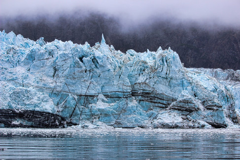
At the top of the bay, we saw pieces of ice floating in the water, increasing in number as we reached the Margerie Glacier, one of the park’s tidewater glaciers (meaning the glacier extends into seawater).

Jeannette and Doug had visited Glacier Bay during our 1985 Alaska trip, and the glaciers are less active now compared to then. We didn’t see any instances of icebergs breaking off the glacier and calving into the sea. However, a tidewater glacier is still a magnificent sight and we hung out with the engine off for about 30 minutes, occasionally hearing small chunks of ice falling into the water.


On our return trip, we paused for a glance at the huge Johns Hopkins Glacier from about 5 miles away…

…and passed Lamplugh Glacier where several glaciers merged into each other.

As we neared Bartlett Cove, six children-of-all-ages took the Junior Ranger oath (see video below).

That evening, we attended a program at the Xunaa Shuká Hít tribal house (a joint project of the NPS and the local Huna Tlingit tribe).


A Tlingit elder Zoomed in to share the history of the Tlingit in the area, the creation of the National Park and how NPS restrictions impacted the traditional life of the tribe.

It took many years for the rights of the local tribe - to use the resources of the area as they traditionally had - to be fully restored. An outgrowth of those efforts to rebuild the NPS-Tlingit relationship was the construction of the tribal house.
The elder spoke of the challenges the tribe faces with keeping its traditions and languages alive and ensure their culture and traditions are passed to the next generation. Recently, the local schools have begun teaching the native Tlingit language as well as English.
We spent the next day hiking in the local area (including a ranger-led walk on the Forest Trail) until it was time to leave for our 5:30 pm flights out and our return to Anchorage.
It was again time to move on to a new part of Alaska, and we headed south for the 4½ hour drive down the Kenai Peninsula to the town of Homer. We didn’t know quite what to expect but found Homer to be a vibrant and very interesting community that sits in a spectacular natural setting. The town sits on a hillside, and below town the six-mile-long Homer Spit stretches out into Kachemak Bay. The mountains and glaciers of Kachemak Bay State Park on the other side of the bay provide a dramatic backdrop.

We camped in an RV park where we had an unobstructed view of the bay. When the tide goes out, expansive tidal flats are exposed, and we explored along the coastal area.


The next morning, we boarded a Bald Mountain Air floatplane and flew to Katmai National Park, about 1½ hours southwest of Homer.

It was our chance to see huge Alaska brown bears fish for salmon at Brooks Falls (one of Doug’s bucket list wishes). The flight over was beautiful, giving us a great view of snow-capped volcanos lining the horizon.
We landed at the NPS’ Brooks Camp where we first had to attend “bear school” (safety and viewing tips) before we could move on. Huge numbers of bears congregate at Brooks Falls each July to load up on salmon as they work to fatten up before winter hibernation. Although bear are usually intent on their task, the Park Service has worked hard to keep both bears and people safe.
The 1.2-mile trail to the viewing sites passes over wetlands and streams. There were elevated boardwalks, protected by electric fence wires, over the wet areas to keep bears and people separated.


There was a special picnic area, protected by electric fencing, and any food (except for plain water) had to be placed in a bear-proof locker before proceeding to the falls. They are very serious about safety!

To avoid stressing out the bears only 30 people at a time are allowed on to the viewing platform closest to the falls, and each visitor can only spend 30 minutes on that platform (they time you and tell you when you need to leave). So, once we approached the viewing area, we put our names on a list and waited in a another viewing area 100 yards below the falls.
From there, we were able to observe approximately 20 bears standing in the river searching for salmon. Whenever a bear successfully snagged a salmon, they would carry their catch to the nearest rock or river side to chow down. Occasionally, another bear would take a great interest in their neighbor’s catch and growling matches would ensue.
One older bear stood downstream from the falls. He would occasionally poke his head under water to watch the salmon, and about every 20 minutes he managed to snag one.


A mother with a young cub was teaching it the fine art of salmon pouncing. The cub diligently pursued a salmon and, after many unsuccessful pounces, finally got one. The mother got the cub to the riverside where the two of shared the salmon.


Another bear got too close for comfort and the mother didn’t even growl a warning - she charged the other bear who quickly left the area. Other bears took note and quickly returned to their fishing spots.
After an hour-and-a-half of waiting, our names were called, and we walked to the upper viewing platform that afforded a close-up view of the bears perched on the rocky edge of the 4-5 foot high waterfall.

From this vantage point we had a great view of the bears’ balancing act of standing on slippery rocks while reaching to grab wriggling salmon attempting to jump the falls.

Mothers with cubs claimed the best perches on top of the falls and several bears that got too close were chased down by the moms. One bear even got pushed from the top of the falls into the water below.


Bears do not have the best vision and several salmon, visible to us from the platform, swam close to the bears waiting below the falls completely unnoticed. It seemed that only 1 in 20 jumping salmon were snatched by the bears at the top of the falls. Salmon missing their mark fell back into the pools and then were pushed up to the surface by hydrostatic pressure so the bears at the bottom of the falls had a chance to snag them in the frothing white water. It was all fascinating to watch.
All too soon, a ranger came to tell us our 30 minutes were over. We hiked back to the ranger station and on the way spotted some bears further down the river.


As we approached the visitor center, we could see and hear two large bears fighting about something. At one point they were both on their hind legs. (Sorry, no pictures). Eventually one of the bears retreated – no lasting harm done.
As we were boarding the plane for our return to Homer a brown bear came trundling down the beach. We had to board quickly and some of the passengers need to step up onto the pontoons to stay out of his way as he ambled right under the tail of the plane.

On the flight back, we flew over some other parts of Katmai NP viewing snowbanks, rivers, and lakes that dotted the land.

Once over water, we flew by Mt. Augustine, a volcano that has created its own island in the bay.

We decided to eat dinner on the Spit and had a delicious grilled seafood sampler at Captain Pattie’s Fish House.
The following day was a chores day. However, we decided to stay in Homer an additional night so we could do a hike that was highly rated on TripAdvisor.
The next morning, we rose early and drove down to the Spit. We had arranged for a water taxi to take us across the bay to Kachemak Bay State Park so we could hike up to Grewingk Glacier and the beautiful lake at its end. After crossing the drop-off beach, the trail heads very gradually uphill through a cottonwood forest.


As we got closer to the lake, the trees thinned out and gave way to smaller bushes.


Soon we could see some of the glacier in the distance and after a final bend in the trail we came on the lake with the glacier serving as a backdrop.

The lake was filled with icebergs that had calved off the glacier and been pushed by wind into a jumble at the end of the lake.

This is a popular hike (“family-friendly” was an oft-used description), and other parties strung out along the gravel beach as we ate our lunch.

We walked along the shoreline for about an hour, taking pictures and admiring the view.


After a couple of hours we started back, taking the Saddle Trail down to a protected cove where we’d arranged for a water taxi pickup.

The last half-mile was a very steep descent, with ropes for safety and at one point a set of oversized steps that ended in a jumble of large boulders that we had to make our way across. While waiting on the beach we chatted with the four other hikers who’d come over with us in the morning’s water taxi.

Back in Homer, around 10:15 pm we felt the RV swaying rhythmically and, since both of us were sitting still, realized the motion we were feeling was an earthquake. We had noticed Tsunami evacuation signs on the highways and, being a short walk from the shores of the bay, we decided to immediately evacuate the area. Jeannette gathered the car keys, cell phones, purse, Doug’s wallet and her meds, while Doug checked online and learned that an 8.2 magnitude earthquake had just occurred several hundred miles southwest of us in the Aleutians. We were already getting on the road out of town into higher elevations when the tsunami sirens in town started to blare.


Although we thought our rig was probably high enough above the waterline (probably 75-100 feet) to be safe, we didn’t want to take chances. We were very thankful that we had not camped down on the Spit since there would have been about a five mile drive at sea level before any elevation gain. We were not sure what evacuation procedures were and just tried to get as much elevation as possible. At the crest of the road, we turned into a scenic view turnoff. Cell phone connectivity was bad and we tried to find a local radio station. We finally found one that had a repeating tsunami warning estimating a 1:15 am arrival of any tsunami crest. We spoke with several locals who told us that the local high school was the official evacuation center but that we were at an equivalent elevation. They said that they get 2-3 of these tsunami warnings each year, but they are usually canceled fairly quickly. The continued blaring of the siren made them think that this was a bit more serious, especially since there had not had a quake of that magnitude in Alaska for decades.
We listened to the local radio station as we waited, and by 12:30 am the tsunami alert had been downgraded to an advisory and was then cancelled. Disaster averted, we returned to the campground and went to sleep.
The next morning, we departed Homer and drove around to the other side of the Kenai Peninsula to the town of Seward (named after the Secretary of State who bought Alaska from the Russians, an act called “Seward’s Folly” at the time). Seward is the gateway to Kenai Fjords National Park and that adventure will be in our next blog post!


Comentarios