
North Dakota, Our 50th State
- dougsmith51
- Jun 23, 2021
- 5 min read

OK, technically, North Dakota was the 39th state to join the union. However, it was also the one state that neither Jeannette nor Doug had ever visited. When we crossed over the border on June 13th, it became OUR 50th state.
Given this distinction, we wanted to spend a few days there, not just drive through on I-94. Fortunately, the North Dakota state tourism agency had provided a helpful guide of 30 Must-See Places in North Dakota to choose from. It might contain some must see items for your bucket list.
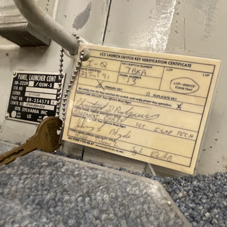
We drove through Fargo, but did not spend any time there, choosing to camp instead in Valley City about an hour west. We first drove north to visit the Ronald Reagan Minutement Missle State Historic Site, a decommissioned control bunker for 10 Minuteman ICBM missile silos. Missile crews would be deployed for stints from nearby Grand Forks Air Force Base. We were able to see the crews' living quarters...


...and then took the still-operational freight elevator sixty feet underground to the highly-bunkered control room where two officers would be on duty for a 24 hour period each four days, ready to push the button (actually turn a pair of keys) if ordered by the President.


On our way back to the campground, we stopped by the National Buffalo Museum in Jamestown. They had interesting exhibits on the history and uses of the buffalo, the taxidermied remains of White Cloud, an albino buffalo who had been part of the museum's herd, and the Buffalo Hall of Fame, dedicated to scientists, ranches, and others (e.g., Theodore Roosevelt) who had helped to safe the buffalo from extinction (numbers have grown from less than 500 at the end of the 1800s to over 400,000 today).


Nearby, Doug insisted on getting his photo taken with the World's Largest Buffalo, visible from the interstate. The quest for Americana continues!

We moved west to Bismarck, the state capital. We stayed at Fort Abraham Lincoln State Park, site of a Civil War post, on the banks of the Missouri River at its confluence with the Heart River. The state park is located on the historic site of the On-a-Slant Mandan village, and they have restored five earth lodges with exhibits about this Native American tribe famed for their farming and trading skills. Current day Mandans donated a lot of items which their ancestors would have used in the old villages, which really added to the exhibit. Unfortunately, the original village had been ravaged by two smallpox epidemics and had been abandoned in the late 1700s, prior to the arrival of Lewis and Clark. They had to search further upstream to find the Mandans whom they knew to be friendly and would help them through the winter.


We drove 50 miles north to the state-operated Lewis and Clark Interpretive Center which focused on the expedition's first winter camp near villages of Mandans and Hidatsas on the Missouri River. Nearby, there is a reproduction of Fort Mandan, Lewis and Clark's winter camp. Various period items were on display based on the extensive records the expedition kept of the nearly 30 tons of materials they carried with them. Can you imagine the excess luggage charges they would have incurred if they flew?


The actual site of Fort Mandan has not been found, and may well have been swallowed up by the Missouri River as it changed its course over the past 200 years.
Leaving Bismarck, we headed west to Theodore Roosevelt National Park, the only national park named after a person. TR visited the area when he was younger, and it was instrumental in his becoming a strong conservationist and fueled his drive to save the buffalo from extinction.
First however, we took a spin along the Enchanted Highway, a 25 mile stretch south from the interstate where a local artist led a bunch of farmers to create seven large welded sculptures that would lead visitors to the small town of Regent. He hoped that this would help his hometown's economic outlook.


Most of North Dakota looks like this - flat, small family farms, as opposed to the sprawling agra-business farmland in the Midwest.

Driving west on I-94, suddenly (and we mean suddenly) we came upon a badlands ecosystem with colorful hills and canyons. That was the beginning of Theodore Roosevelt National Park.

The National Park has two units (south and north) about 50 miles apart, and we were able to visit both. The south unit, close to I-94, is particularly famed for its wildlife. We were able to spot buffalo right by the road while driving the park's scenic drive.

It's important to view buffalos from your car. They are bad tempered and pretty dangerous and the Park Service offered this charming warning.


The park also has herds of wild horses.
Finally, we spent time admiring the huge prairie dog towns (really, prairie dog cities) and listening as they chirped their warnings and scampered from one burrow to another. We also saw that the prairie dogs and buffalos peacefully co-exist.


Prairie dogs are very cute, and one would be tempted to offer them treats, but as another Park Service sign says: "A fed dog is a dead dog."

We saw a mother prairie dog and two tiny babies not far from where we were parked to quietly observe them.

As the sun lay low on the horizon, we hiked up to a 360 degree view at the highest point in the southern unit.

The next day, we drove 50 miles to the north unit of the park, passing by Little Missouri River National Grasslands (we didn't know there was such a thing as a National Grassland - will we have a National Lawnmower next?) maintained by the U.S. Forest Service.
We found the north unit more impressive than the south unit, with higher hillsides, wider canyons, and truly beautiful scenery as opposed to just being dramatic.

On the scenic drive, we came to a group of spherically shaped "concrete accretions" formed when minerals in the water "glued" some sediment material together and the fast flowing water carried it along, gathering more mass on it's travels. They were imbedded in the sandstone formation and gradually erosion has exposed them.

We decided to tackle a three hour hike on the Capstone Coulee loop trail. We parked under a copse of cottonwood trees, which tend to grow near creeks and streams. They just dropped their seeds, creating a soft fiber "carpet" which is how they got their name.

A steep climb of about 500 feet at the beginning of the trail took us up on top of the mesas. We were able to see the Little Missouri River winding below us.


We happened upon what we're pretty sure were 55 million year-old petrified logs.

We also saw red day lilies flowering alongside the trail.


Toward the end of the trail, we descended through forest, and came upon a "capstone" that the trail is named for - harder rock sitting on top of softer weathering rock.

We then met up with an NPS nature trail. Looking across the way, we could see more petrified logs dropping out of the hillside.

Before ending our hike, Jeannette could not resist a typical "Doug pose" on a rock sticking out of the eroded sandstone.

After ending our hike we drove to the end of the 14-mile scenic drive to an overlook of an ox-bow curve in the river that will eventually be cut off from the main river and form a lake.

Driving back toward the entrance, a buffalo herd crossed the road in front of us dutifully following the matriarch of the herd who paused to make sure traffic stopped before crossing. There was a young calf with none of the characteristics of adult buffalo, in fact it looked more like a cow calf.


That evening, we attended a ranger presentation on bats at the campground (the return of ranger programs welcome as a sign that we are getting past COVID). We then drove further into the park to an astronomy program run by a husband wife time who do this on a volunteer basis each summer.
The next morning, we packed up the rig and headed into Montana for more adventures. You can hear more about that in an upcoming post!


Just loving these adventures! Keep 'em coming.