At the end of our last blog post, we were still at the bottom of the South Island. As much as we'd loved the mountains, lakes, and fjords, it was time for new adventures. We spent three days driving to the top of the South Island. Our destination was Abel Tasman National Park. We'd not explored much of the New Zealand's east coast during our 1987 visit, so decided to come up by that route.

The route up to and past Christchurch was largely agricultural, passing many sheep farms (there are many more sheep in New Zealand than people).

North of Christchurch, the road became increasingly winding as it hugged the coast between high hills and mountains.

We stopped in the town of Kaikoura for a lunch of seafood at an outdoor stand, marveling at some very interesting limestone rocks off shore.

Our home base for Abel Tasman National Park was the town of Kaiteriteri, with beautiful sand beaches.

Our campground was right at the beach front, facing the sunrise.
The Abel Tasman Track is another New Zealand's "Great Walk," and one of the most popular. It takes three days to complete. However, it's easy to hike a portion of the Track by using a water taxis to drop you off at one location and pick you up at another, and that's what we decided to do. We drove about 15 minutes north of Kaiteriteri to the small town of Marahua to start our adventure. Interestingly, the Abel Tasman Aqua Taxi picked us up in the parking lot with the boat riding on a trailer pulled by a tractor. The tractor then pulled us down to the boat ramp and into the water.

Before starting north along the national park, we visited Split Apple Rock, a favorite photo location.

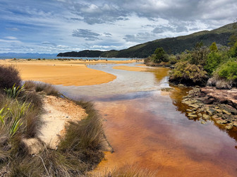
The scenery was beautiful, mostly forested and punctuated by beaches and islands along the way. At one island, we watched a male fur seal sunning himself. We also pulled close to a limestone cliff with a couple of arches.

Finally, we were dropped at Onetahuti Beach. The captain was able to get close to the beach but it was a wet landing, so we went off the boat barefoot with our pants rolled up.

We sat on a log to put on our hiking shoes. A seagull with red legs and red eyes joined us. Nearby, we saw an oyster catcher with a long orange beak. A lagoon, refilled at each high tide, lay on the other side of the beach.

Starting our hike in earnest, we walked for about two hours. First we walked along the very long beach, then across boardwalks, up through a forest with a lot of ferns and, after we crested the ridge, a view down to Awaroa Beach. We had a delicious lunch of fish tacos at the Awaroa Lodge before meeting the water taxi to take us back to Marahau.
Thus ended our South Island adventures!

We left Kaiteriteri and overnighted at the town of Picton. The next morning, we drove to the docks and boarded the Interislander Ferry for our three hour cruise to the North Island. Because of the way the two islands are situated, our route took us slightly southeast rather than north.

The ferry lands in the city of Wellington, and we freedom-camped at the marina' parking lot for a couple of days while we explored the city.

We signed up for a tour of Weta Workshop, the special effects company most famous for Lord of the Rings, although they've assisted in dozens of other films. We did not tour the digital effects spaces (which would have been pretty boring, watching people work at computers) but we did go through spaces and exhibits related to physical effects such as props, miniatures, prosthetics, costumes, weapons and swords, and so forth. Our guide was super enthusiastic, and the tour was a lot of fun. We were only permitted to take photos in a few areas.
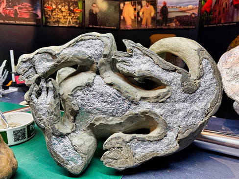
As part of our tour, we learned how Weta uses an inexpensive technique for making statues by crumpling aluminum foil and shaping it into underlying armatures, then covering with a quick-setting clay. The picture on the left shows the aluminum foil base covered with clay, the one on the right shows the finished product before painting.
Wellington is a bit grittier and older than other New Zealand cities we've visited. We learned that after the Christchurch earthquakes, the national government required that all existing New Zealand builadings be brought up to 67% of the latest earthquake-resistant building standards. A number of building owners decided instead to close their businesses, like the Amora Hotel, "landbanking" the underlying real estate that they hope someone will buy in the future.

We spent two partial days visiting the Wellington's National Museum of New Zealand.

They had a very moving exhibit about Gallipoli, a World War I battlefield in Turkey where many ANZAC (Australia-New Zealand Army Corps) troops were sent and where the casualty rates were very high before the British decided to give up that particular battlefield. There's still a sense that many lives were lost for little purpose and the memories run deep.

The exhibit focused on stories of individual soldiers, officers, doctors, and nurses and was very moving. It also featured several 4X-life-sized statues made by Weta Workshop.

We returned to the museum another day to go through exhibits about Maori history and culture, and another exhibit about how settlements, first by Maoris and then by Europeans, has affected the ecosystem.
Maoris came to New Zealand about 800 years ago, arriving from a land called Hawai'ki (not Hawaii) that is probably near the Soloman Islands. They visited seasonally for a number of years, learning to live in a much colder climate (it's November here, the equivalent of our May, and the temperatures still go down to 50 or below at night and only get to the 60s or low 70s during the day). Finally, they relocated for good. There was an excellent exhibit about ocean navigation techniques perfected by Polynesians and used by Maoris.

There was also an exhibit about the 1840 treaty between Great Britain and the Maoris, where wording differences between the English versions and Maori versions (e.g., on concepts like sovereignty) have caused ongoing friction. Large transcriptions of the treaty hang on the museum walls. The English version was defaced in 2023 by Maori protesters, and that space is currently covered by a video program explaining the differences and the conflicts.
We think, however, that Maoris have made out better than indigenous peoples in other countries like Australia and the U.S., and there are ongoing discussions about rights and reparations. The museum contains a modern Meeting House where ceremonies are held and it specifically says the House is for all New Zealanders. Many of the carings in panels celebrate various trades and professions in New Zealand.

From Wellington we drove north for about four hours and camped on the shores of Lake Taupo (pronounced TOE-pour), New Zealand's largest lake. On the way we passed Tongariro National Park, which contains three volcanos and another Great Walk, the Tongariro Alpine Crossing.


Here are a couple photos of us hiking through Tongariro in 1987. Snow had fallen and brightened the otherwise black volcanic landscape.
While in the area, we took a cruise on Lake Taupo to see a 40-foot-high Maori cliffside carving made about 50 years ago, which celebrated the ancestors of the artist's mother.


Originally, the plan was to travel by sailboat, but high winds on the lake were causing waves (see video below) and we went by powerboat instead.
Then it was on to the town of Rotorua, New Zealand's hub for geothermal activity and Maori culture. But that'll be covered in our next blog post, stay tuned.


















Comments