
Continuing south from Wanaka, we drove twisty roads through mountain passes and arrived in Queenstown. Queenstown is the self-proclaimed adventure capital of New Zealand, and it's an incredibly popular tourist spot. We were lucky to visit during the shoulder season, where it wasn't TOO crowded and we were able to get into activities and restaurants without problems.
We camped at a holiday park which was only a five minute walk from downtown. We were packed in like sardines, but given the difficulty of finding parking in Queenstown we weren't complaining.

The town sits on Lake Waketipu and is faced by a range of mountains called (no joking) The Remarkables. The setting is stunning, as you can see by this view from the campground.

The town itself has grown considerably since we visited in 1987, and its streets are full of gift shops and made-in-New-Zealand-woolen stores. You can find, within a 100-foot radius, Starbucks, KFC, and McDonalds.


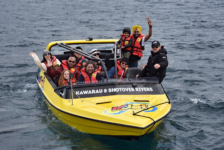
On the afternoon of our arrival we booked a jet-boating adventure. We'd jet-boated on through Shotover Canyon in 1987 and it was quite the thrill!

This time we decided to use a different company, KJet, that offered a longer ride across Lake Wakatipu and up two rivers. It wasn't quite the narrow canyon experience but it was still fun. The pictures and videos below are a combination of our own and photos we purchased from KJet.
There's another adventure that we didn't do (maybe we would have been game 37 years ago...). It's called Hydro Attack, and seems like a combination jet-ski and submarine. Be sure to watch the video below to the end.

On our second day in town we booked a lake cruise on the TSS Earnslaw, a coal-powered steamer that's been navigating Lake Wakatipu for 110 years.

It was a gorgeous sunny day, showing off the lake, the shoreline, and The Remarkables to advantage.

After our cruise we rode a gondola up above town for a commanding view of Queenstown and its environs.

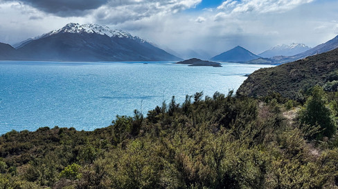
Queenstown sits at one end of Lake Wakatipu and for our last day in the area we decided to travel to the other end. The drive down the lake is stunning, billed as one of the top drives in New Zealand.
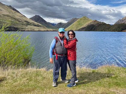
On the way, we drove a few miles inland from the lakeshore and hiked around beautiful Moke Lake.

We camped overnight in the delightful little town of Glenorchy. There's a much-photographed old red train station and we added our photograph to the many that have been taken there.

We also walked around the town, although it was super windy by the lake and rain settled late in the day. It rained all through the night and continued much of the next day. Originally, we'd planned to drive from Glenorchy to Milford Sound, but the Milford Sound road was closed for a day-and-a-half because of avalanche concerns. Fortunately, we had a campervan and some time flexibility. We drove instead to the town of Te Anau, which is the gateway for Milford Sound and more broadly for Fiordland National Park, and stopped by the tourist information office to book a couple of future activities, then drove 20 km north of town to a national park campground on the shores of Lake Te Anau.

It's the second largest lake in New Zealand. We traveled by boat to the head of Lake Te Anau 37 years ago to start our hike of the Milford Track, one of New Zealand's "Great Walks."

Fortunately, the road to Milford Sound had re-opened by 10 am Friday morning, and we started our drive in.

Along the way, we stopped at several pull-offs to take pictures of the dramatic scenery ahead. First, we passed yellow meadows hemmed by mountains on both sides.
We stopped by a spot called Mirror Lakes to catch reflections.

As we started driving uphill to the pass, we paused by raging streams filled by the recent rains. At one spot, the water is so pure tourists can fill their water bottles from it (we didn't).
We continued to climb higher and higher.

We passed one cause of the road closure - a large rock and mud fall. The crews were working through the rain to clear the road. We were not able to stop and take a picture because of the continuing avalanche danger. We finally approached the Homer Tunnel. It's a one-way-at-a-time route governed by stoplights, and we had to wait about eight minutes before traffic in our direction was allowed through. While we waited, we marveled at the many, many waterfalls cascading down the cliffs (many of the smaller waterfalls only flow after heavy rains).
We were also visited by some keas, New Zealand's alpine parrot.

Finally, we crossed through the tunnell and started the long winding descent. There were a lot of "No Stopping - Avalanche Hazard" signs so we could not pause to take pictures. We did pull off into a parking at an area called The Chasm (with a name like that, how could you not stop?) and took a short hike through green, mossy, rainforest.
We could see that there was a narrow gorge carved out by water. Unfortunately, all three bridges leading over the gorge had been washed out in a 2020 storm, and work was still underway to replace them.
Finally we arrived near Milford Sound and checked into the campground operated by Milford Lodge. They'd been good about changing our reservations because of the road closures. We learned that in a normal year, the road is only closed about 8 days - this year was definitely above-average.

We walked the 45 minutes from the campground down to the boat docks to get some exercise and check in for our 3:15 pm cruise. We'd deliberately picked the last cruise of the day when booking in Te Anau to give us flexibility in case of road issues. There are about five different cruise lines which operate almost identical cruises through the Sound. We'd picked Southern Discoveries and took adanctage of their 20 percent off sale.

Milford Sound is long and relatively narrow, a true fjord with high mountains rising straight out of the water. The iconic Mitre Peak, a mile high, is the highest.

We maneuvered close to the shore line, and had to crane our necks to see the cliff tops. It felt like being in Yosemite Valley, except filled with water! Again, due to the rain, there were dozens of waterfalls and swollen cascades tumbling down. Some were temporary, due to the recent rains, and other larger ones were permanent, fed by glaciers perched high above out of sight. We could also see streams feeding into the fjord.
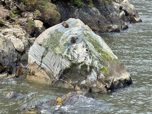
We sailed out to the fjord entrance, where the Tasman Sea lies between New Zealand and Australia, and then back into the Sound. On our return, we found some fur seals basking on a large boulder - they look like little fat sausages.
The sky continued to clear during our cruise and we were lucky to be able to see the tops of all the surrounding mountains clearly by the time our cruise ended.

We'd lucked out with the weather, and rekindled some happy memories of the past. Even though our path to Milford Sound was radically different this time around, the magic was still the same.

We walked the 45 minutes back to the campground, cleaned up, and then had a delicious dinner at the Milford Lodge's restaurant, Pio Pio, including lamb ribs where the meat literally fell off the bone. Delicious!
As we walked back to the campervan, we caught the last rays of the setting sun on the mountaintops.

We'd gotten an email notice that snow was expected the next afternoon and more road closures were anticipated, so we left Saturday morning (rain and clouds had returned) and drove the hour-and-a-half back to Te Anau.

On Sunday, we'd booked another cruise in Fiordland National Park, this time to Doubtful Sound, which sits south of Milford Sound. To start our journey, we drove south to the town of Manapouri, about 15 minutes away, and boarded a boat which took us across Lake Manapouri, the fifth largest in New Zealand.

Lake Manapouri was created in the 1950s by damming the Manapouri River. Its powerplant has only one customer: an aluminum-smelting plant in south New Zealand. Smelting takes vast amounts of energy - the dam could otherwise power over 600,000 homes.
After we arrived at the dam, we boarded buses which drove another 55 minutes, taking us over a mountain pass.

We stopped for photos, and could see Doubtful Sound laid out beneath us. Our bus driver told us it was the first time that view could be seen in over two weeks - we felt fortunate.

Finally, we boarded another ship for our cruise through Doubtful Sound. Like Milford Sound, it's a fjord. It was named by Captain Cook when he expressed his doubts that he would be able to find an anchorage in it and still be able to successully exit.

The mountains don't rise as steeply as the do in Milford Sound, but there are lots of interesting twists and turns and side channels continually opening up new vistas.
Because the winds were unusually calm, we were able to exit one channel into the Tasman Sea and then re-enter through another channel.

The most special moment came when we were in a side arm of the Sound - the captain invited us to step out onto the decks, and then turned the engines off for almost 10 minutes. Profound silence, broken by bird calls and gentle waves lapping the shores. It was magical!
At the end of the cruise, we reversed the earlier journeys of the day, crossing the mountain pass in buses and boating across Lake Manapouri. We returned to Te Anau for the night.
Solidifying our plans for the next week, we decided we would drive long hours for the next three days to reach the top of the South Island. We wanted to visit Abel Tasman National Park before taking the ferry across to the North Island. But that's a topic for another blog post...

















Comments