That's what the license plates say. And, we have to admit, Michigan is a beautiful and largely rural state, once you get away from the Detroit area. It's one of the few states divided into two non-contiguous parts (interestingly, our home state of Virginia is another).
After leaving Detroit, we spent 10 days traveling around Michigan's lower peninsula. It's sometimes referred to as "the mitten" because it is definitely shaped like one.
NOTE: By the way, did you know that our website's "Maps" tab shows our route-so-far, not only for this year but since we started traveling in 2019. You can also see where we're currently located, as well as our planned route for the next couple weeks. Check it out!
The mitten is bordered by Lake Huron on the right and Lake Michigan on the left, with the Straits of Mackinac connecting the two at the top. We started our exploration by driving from Detroit up to Oscoda on Lake Huron, about two-thirds up the peninsula. Our first evening, we drove the short distance from the campground to the town of Oscoda and took in Lake Huron from the town beach.

The next day, we explored the River Road Scenic Highway which follows the AuSable River from the interior to Lake Huron, running through Huron-Manistee National Forest. The AuSable was a major transportation waterway in the 1800s for logging and other resource extraction. In the early 1900s six dams were built along the river, so now it looks more like a series of lakes.

The River Road rides atop sandy banks 200-300 feet above the river, affording some dramatic views.

There are a number of stops along the road. At one, we hiked down 300+ steps...

...to visit Iargo Springs. The springs come out at the bottom of the hill, providing a constant flow of fresh cool water into the AuSable.

We hiked the 300 steps back up to the car (we're finally getting back into shape for these summer adventures) and drove to see the Lumberman's Monument, dedicated to the lumberman who worked these forests in the 1800s.

The following day, we packed up camp and drove to Mackinaw City at the tip of the Lower Peninsula. That served as our jumping off point for a visit to Mackinac Island (don't ask us why they're spelled differently, although both are pronounced "-aw" at the end). This was our third visit to the island. The first time was during our 2002 RV-Across-America trip with our kids, and the second was in 2021 toward the beginning of our Alaska trip as we were traveling across the top of the US on our way to Bellingham, Washington to put the Ciaowagen on the Alaska state ferry.
We took a ferry from Mackinaw City...
...traveling under the "Mighty Mac," the five-mile-long suspension bridge (longest in the Western Hemisphere) that connects Michigan's Lower Peninsula and Upper Peninsula.

One of Mackinac Island's claims to fame is that no motorized vehicles are permitted. Thus, everything is delivered by horse-drawn wagon.
Since we'd visited the island before, we decided to explore some of the back streets and hills of the small town which sits at the bottom of the island. This took us past the famous Grand Hotel (where they charge you $10/person just to walk through the front door if you are not staying there).


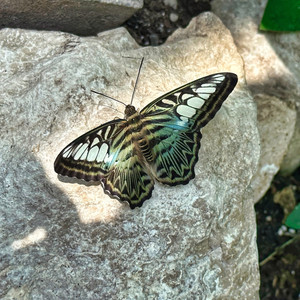
We visited a butterfly conservancy, where we saw many beautiful species, including one that decided to hitch a ride on the back of Jeannette's blouse for about 10 minutes.
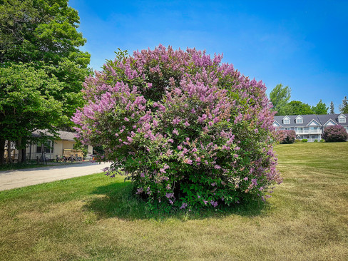
The lilacs were blooming when we visited the island, and there were other beautiful flowers decorating the Victorian homes and inns.

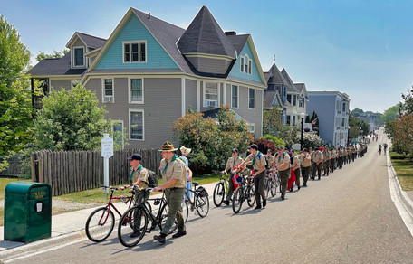
In addition to horses, bicycles are ubiquitous on the island.
Over 80% of the island is a Michigan State Park, and an eight-plus-mile bike path winds along the shoreline.

We got bikes from one of the many rental companies on the island and rode the shoreline circuit. It's one of our favorite activities to do there.


Moving further counter-clockwise around the peninsula, we traveled to the Traverse City area. It hosts a National Cherry Festival each year, but we arrived a week too early for that.
While in the area, we went to Sleeping Bear Dunes National Lakeshore, managed by the National Park Service. We'd visited Sleeping Bear Dunes on our 2021 travel to Bellingham, Washington, and remembered the beautiful views of Lake Michigan from atop the dune line.

This time heavy fog had rolled in from Lake Michigan, giving the area an other-wordly and mysterious quality.


Climbing the 400+ foot high dunes is an activity...

...but we declined after seeing this warning sign.

Instead, we took a forest hike along the Windy Moraine trail.

Before leaving the Traverse City area, we had a very nice dinner with an old AMS colleague of Doug's, Mike Dow, and his wife Melissa, who settled in the Traverse City area to raise their daughters.

We moved on to our last peninsular location: Covert, Michigan. It's located close to the beach town of South Haven, and we traveled there for the afternoon to walk along the waterfront and the beach. The Black River flows through town and empties into Lake Michigan, with frequent boat traffic from the town marina.
A historic lighthouse guards the entrance to the river channel.
Even though it was a weekday, the town's beach was crowded.

Unfortunately, Canadian wildfire smoke had come back, making the air unhealthy (Code Red), so we masked up with some KN-95s left over from COVID.
We'd enjoyed our visit to Michigan's Lower Peninsula very much, but it was time to move on - this time to Wisconsin on the other shore of Lake Michigan. More about that in our next blog entry.


Comments