

While the primary focus of our 2023 RV trip was circuiting the Great Lakes, we'd always planned on a side trip to the Black Hills. We'd visited the area in 2002 on our first RV trip ever, and had stopped just in at Mount Rushmore and the Badlands in 2019, so wanted to refresh our memories and explore the area in more depth. We headed south from the Michigan's Upper Peninsula on July 20, and didn't return to the Duluth area until August 1. The trip to the Black Hills took two days to complete in each direction.
We'd had a very good time exploring Patagonia earlier this year with our good friend and neighbor Kim Cox, and when Kim expressed interest in the Black Hills, we said "Sure, fly out and join us for the week."
During our trip out to western South Dakota, we crossed into two time zones (first Central, and then Mountain). We overnighted in the town of Mankato, MN, south of Minneapolis before setting up in Interior, South Dakota for four nights to explore the Badlands.

As we came back to Interior after picking Kim up at the Rapid City airport, we stopped in the town of Wall to visit famous Wall Drug. For those of you not familiar with Wall Drug, it's the South of the Border of the midwest, with an ever-increasing number of billboards on I-90 as you approach from either direction.

We had a campsite at the Badlands/White River KOA, and Kim stayed in one of their Kamping Kabins, a little bungalow with air conditioning, kitchenette, and bathroom, since there were no available motels in the area.
The next morning, we drove just north of Badlands National Park to visit Minuteman Missile National Historical Park.

When the START treaty was signed in summer 1991, the U.S. needed to shut down half of the 300 missile silos located in the upper midwest. There had been three missile squadrons based out of Ellsworth AFB in Rapid City, each squadron with a control center and 10 missile silos. Each silo was located three miles or more from the control center or another silo, so that they could not be knocked out by a single nuclear explosion. All three squadrons were deactivated. Two of the silos and the control center of Squadron 66 became the NHP.

By reserving early, we were able to snag an in-person visit to the control center. Tours are limited to six people max, and we were joined by a couple visiting from the Netherlands. The park ranger giving the tour had served in that control center 30-40 years ago while in the Air Force, and was very knowledgable. We'd been in two other Cold War-era missile locations in 2019 (a Titan missile silo near Tucson) and 2021, a Minuteman contol center that was now a North Dakota state park) but this was still very interesting and a new experience for Kim.

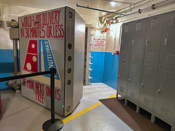
We explored the "Delta-01" control center and learned about the daily lives of the missile techs and support personnel. Taking an elevator down into the earth, and then passing through the massive vault door, we saw the equipment operated by the two missile technicians and were even walked through a simulated launch.


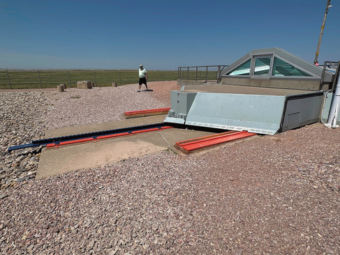
From there, we drove about ten miles to missile silo "Delta-09" where we could see a replica missile and the massive door covering the silo.


Ironically, both of these sites were located less than a half-mile off I-90 - imagine millions of travelers blithely driving by on the interstate unaware during the 1970s and 1980s! As an aside, we learned that providing military transportation axis had been one of the selling points for the Interstate Highway System back in the 1950s.
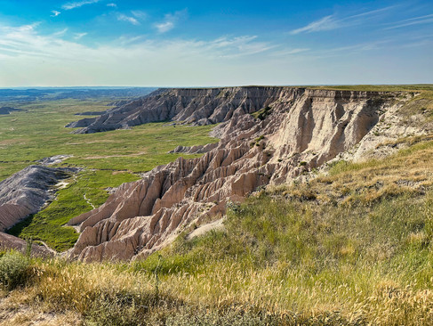
It was extremely hot for most of our time in South Dakota, approaching 100 degrees every day, so we did less hiking than we'd originally expected and more car touring. That afternoon, we drove the main loop road of Badlands National Park, taking in the stark formations and rolling plains, and gawking at a huge prairie dog town.


The next day we rose early to beat the heat and attend an 8:30 am ranger talk on the geology of the Badlands.

It was super interesting! The Badlands were formed millions of years ago, not by sedimentation for ancient inland seas (except for one, small colorful section) as we'd assumed, by rather from dust and soil blowing in during the formation of the Black Hills 50 miles away. Depending on the conditions, over a period of 50 million years different sedimentary layers were deposited, hardened, and buried. The layers began eroding about 25 million years ago, and even though deposition still occurs, erosion now outpaces it, exposing more and more of the Badlands.
We then hiked the Door Trail through some iconic Badlands scenery. The scene is deceptive, looking bigger than it is until you see some other people hiking and get a sense of scale.


As we hiked, we saw a bighorn sheep resting on a nearby mound.

Based on a tip from the ranger who'd given the morning talk, we explored a dry creek bed wash near the Visitor Center, getting ever narrower as we continued uphill.


On our hike back out, we surprised some mule deer on a hillside.

That afternoon, we drove south to the Stronghold Unit of the National Park, which is co-managed with the Ocola Lakota tribe whose lands surround it. The area was used as a bombing training range during World War II. As we explored, we enjoyed fields of sunflowers.


We pulled up stakes the next morning and moved to Rapid City, where we checked into another KOA and Kim checked into a nearby Howard Johnson motel. Over the next few days, we explored up, down, and around the Black Hills.

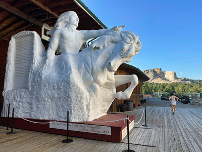
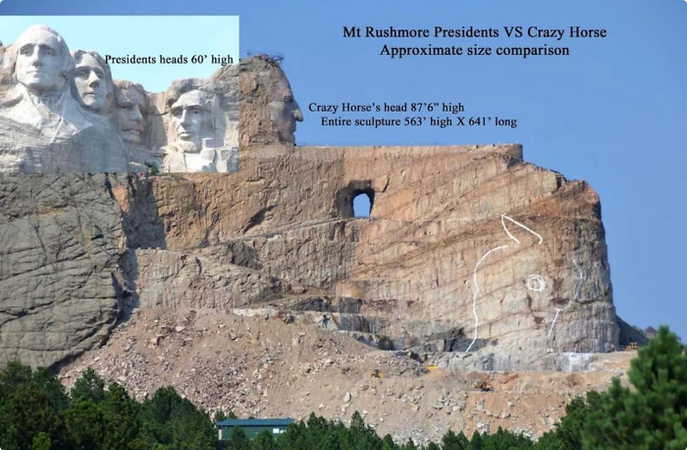
The first afternoon we visited Mount Rushmore and the nearby Crazy Horse memorial, traveling to Crazy Horse first. The memorial is being carved out of an entire mountain, and is a private project started by the sculptor Korczak Ziolkowski, who was asked in the 1940s to carve a memorial to the Oglala Lakota warrior Crazy Horse, riding a horse and pointing to his tribal land.

Eighty years later, the work is still ongoing and a third generation of Ziolkowskis leads a crew of about 20 workers who dynamite, carve, and polish year round. The Ziolkowskis have refused government funding, and the work is paid for from admissions and gift shop and restaurant sales.
We had seen the memorial 20 years ago with our kids, and while sometimes it appears little progress has been made, huge parts of the mountain have been removed and work is progressing on Crazy Horse's outstretched arm and hand. In the next few years, work will begin in earnest in carving his horse. You can also tellthe newer excavations because the rock is a lighter color than the older parts (like Crazy Horse's face) which have weathered more.

Everything about the sculpture is massive in scale:

Once completed, the site will have a large reflecting pool at the base, and will also contain a Native American museum and university, both of which have used up some of the available funding.


Outside the visitor center, you can see a 1/34th scale plaster model of the carving, made by Ziolkowski as a guide. Looking at the model, you can see how truly 3D the conception is.


The site, and mission, are truly impressive. We paid five bucks and took a bus tour to the base of the mountain where we could see the work more up close. You can also visit the top of the memorial for $125/person, but only after work hours and we were there in the afternoon.


We then moved on to Mount Rushmore. It's iconic, and probably the most popular tourist location in the Black Hills.

The presidents are nice, but after visiting Crazy Horse you're struck by how much smaller Mount Rushmore is. See the illustration below comparing the relative size.
After grabbing dinner in the memorial's cafe, we walked to the amphitheater, newly added since our last visit to Mount Rushmore. It can accommodate 2,300 people, and it was almost full.

The evening ranger program consisted of a short presentation by a park ranger (whom we suspected was a former Marine), a 30 minute movie about the memorial and the four presidents on it (Washington, Jefferson, Lincoln, and Teddy Roosevelt), ending with an illumination of the memorial while everyone sang the Star Spangled Banner and veterans were saluted on stage.

Patriotism was definitely the theme of the evening, but the Park Service skillfully dodged any political leanings one way or the other.
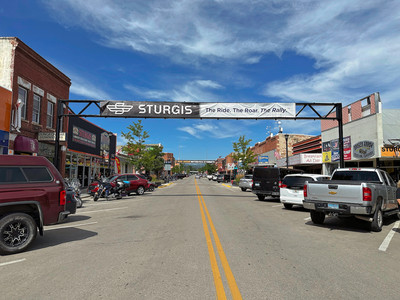
The next day we traveled northwest of Rapid City, first stopping by Sturgis, SD, just a week ahead of its annual motorcycle rally when hundreds of thousands of bikers descend on this small town.


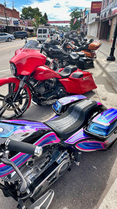
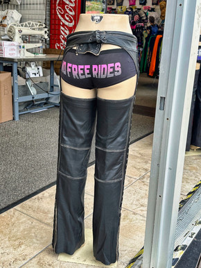
There were lots of pop-up stores in addition to a collection of clothing and biker shops.


There were some pictures of the rally, but it's still hard to imagine so many people cramming into this small town for an entire week.

We perused some of stores, but walked away empty handed when we couldn't find anything that appealed to our Inner HOG.
From there we traveled to Deadwood, SD. We'd visited with our boys in 2002 and remembered a staged cowboy shootout in the main town square. There was one scheduled for later that afternoon, but we didn't stick around.

Deadwood seemed to us to be the Kardashian of Wild West towns - famous for being famous (Wild Bill Hickok was shot in the back there) but with no current charm. There were lots of gift shops and slot machines, not to mention the Beef Jerky Experience.

Sturgis doesn't apologize for what it is. Deadwood pretends to be something it's not. We preferred the former.
Not too far from Deadwood is the southern entrance to Spearfish Canyon Scenic Parkway, a beautiful 20 mile drive through a winding canyon, part of Black Hills National Forest. and we decided to take it in. You get a feeling there for why they call the Black Hills black, between the dark rock, deep green evergreens, and tannic-dyed streams.

It was another hot day, but we stopped about halfway up the scenic drive and hiked to lovely Spearfish Falls.


We returned to Rapid City and visited the Prairie Edge Trading Company, a large artist collective highlighting Native American and Western artists and featuring paintings, photographs, jewelry, furniture, handmade clothing - you name it. Kim fell in love with a tall lamp which she decided to purchase and have shipped home to Virginia. From Prairie Edge, we walked to Tally's Silver Spoon, an amazing restaurant, for a delicious dinner.
Rapid City's downtown is small, but every corner has a statue of either an American President or a famous Native American.


In the evening, we drove south of the city to Hart Ranch Camping Resort and attended an authentic rodeo. Kim had never been to one, and it was our first in over 20 years. There was bareback riding, bucking broncos, barrel riding, and bull riding (the most exciting and the scariest). There was also a strange activity where ladies came down to the arena, took off one shoe, walked to the other side of the arena, then held a race to retrieve their shoe and run back to the starting point. Jeannette and Kim declined to participate, although Doug couldn't understand quite why.

We spent the next day in Custer State Park, a large and amazing place that would surely be a national park if it wasn't already a state park. The landscape varies from rolling hills to craggy peaks. The park also protects from 1,200 bison, although we only saw one (with a newborn calf) and that was outside the entrance to the park. Shortly after entering the park, we drove to one of the highest points to take in the expansive views.

Jeannette struck up a conversation with another woman there, who asked where we were from. When Jeannette told her Virginia, she whipped out a business card to introduce herself as Winsome Earle-Sears, the Lieutenant Governor of Virginia. Small world!

She was there on vacation with her husband, and was being escorted around Custer State Park by South Dakota's Lieutenant Governor and the head of South Dakota Games, Fish and Parks.
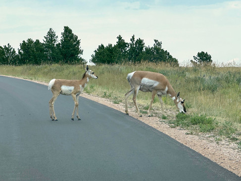
There are three scenic drives through Custer State Park, and we did them all that day. On the first, the 17-mile Wildlife Loop, we kept our eyes out for buffalo but did not see any. We did, however, run into a family of pronghorn antelopes who decided to cross the road, stopping traffic.


We also passed the park stables, and waited while they brought the herd across the road to the paddock.
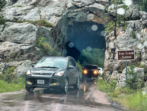
The second park drive was about 20 miles long, and called the Needles Highway. Winding first through a forest, it climbs up to a section of spiky rocks called the Cathedral Peaks. A thunderstorm rolled through during our drive, and we spent about 20 minutes on the side of the road waiting for the rain to pass. Continuing up, the road passed through some extremely narrow and low tunnels. We were glad for our little Honda Fittata!


Finally, we reached the section of the road winding through the Cathedral Peaks. Magnificent!!


There was a roadside sign noting how the idea for Mount Rushmore was born in 1923 during a Model T drive by some big Dakota muckety-mucks through the Cathedral Rocks area.
The drive ended in a final narrow tunnel and a rock formation called the Needle's Eye (you can see why it's called that in the picture below).


We exited the park and drove south to another entrance. Along the way, we passed a farm where they were raising longhorn cattle.

We reentered the state park and traveled to the start of our third scenic highway, the Iron Mountain Road. The road winds uphill through forests and fields. We passed through two more narrow tunnels, both of which framed views of Mount Rushmore in the distance (you'll need to zoom into the pictures to see the Presidents' faces).


On our last full day in the Black Hills, we drove toward the southern end of the Black Hills, first visiting Wind Cave National Park. It was the first of the U.S.' three cave-based national parks (Wind Cave, Carlsbad Caverns, Mammoth Cave) to be designated, all the way back in 1903. It was set-aside because of its unique formations and because it is a very complex cave system (the red lines include the mapped portions of the cave system, which has not yet been fully explored).

You can only see the cave on a ranger-led tour, and we'd signed up in advance for the two-hour "Fieldhouse" tour, somewhat longer than other tours, with more up and down (on steps and ramps). We were able to see portions of both the lower and middle caves. We took an elevator down some 200 feet to begin the tour. While the cave is lit well enough to allow visitors to navigate, it's dark enough to make picture-taking challenging.

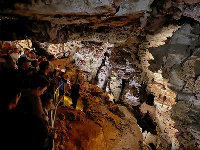


Wind Cave does not have stalactites or stalagmites. However, it has other unique formations, most notably "boxwork," where narrow strips crisscross on the ceiling and walls, reminding early visitors of post office box slots.

We also saw a section where "popcorn" decorated the walls.

Continuing our explorations, we drove south to the town of Hot Springs and visited The Mammoth Site. This site, first discovered in the 1970s by a local landowner who'd wanted to build a small residential neighborhood, is a prehistoric sinkhole where over 60 mammoths were trapped over a period of several thousand years about 20-25,000 years ago.

The landowner donated the site to a nonprofit, which continues to slowly excavate the site, now covered by a large building with walkways that take you around the "bonebed."
Many of the bones have been left in-situ rather than removed. You can see skulls and tusks, and some relatively complete skeletons, as well as massive teeth.


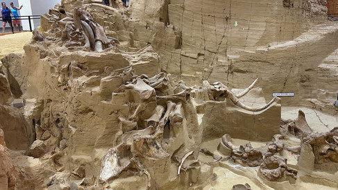


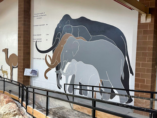

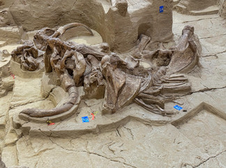


Although three Wooly Mammoth skeletons have been unearthed, most of the skeletons are of larger Columbian Mammoths which looked more like modern-day elephants.
On our trip back to Rapid City, we stopped at Sylvan Lake on the edge of Custer State Park, which we'd driven by the previous day and seen the hiking trail around the lake. The shoreline is dramatic, with much of the lake surrounding by jutting stone towers like those along the nearby Needles Highway.

The lake has been enlarged by a dam, and we saw a number of people swimming, kayaking, and using standup paddle boards.

The hike ranged from paved asphalt trail to dirt to some challenging rock scrambles, but was very pretty. We were glad we'd stopped to do it.


On Saturday morning, July 29, Doug picked up Kim from her motel and took her to the Rapid City airport to fly home while Jeannette got the RV ready for the road. We then drove east on I-90 for about 5 hours (and back into Central time) and stayed at a campground in Sioux Falls. The next morning, we had a delightful brunch with Doug's friend Mike Ridder, who used to be a partner in the same CFO consulting firm Doug was associated with. Mike toured us around the city, which sees to be on quite the new construction roll!
We then continued heading east into Iowa, and checked into the community campground of Forest City, IA for two nights. Forest City is the manufacturing headquarters of Winnebago, where our Ciaowagen was born back in 2016.
We'd arranged to take two factory tours (unfortunately, no photography was allowed). The morning tour, actually about 10 miles away, was at Winnebago's facility for building out camper vans. They acquire basic Mercedes Sprinter vans and Chrysler RAM vans, cut extra windows, and build out the insides with beds, kitchens, small bathrooms, etc.

In the afternoon, we toured the "Big Bertha" factory where Class A (like the Ciaowagen) and Class C (with the bed-over-cab design) motorhomes are built. It takes about five days to complete the build process. Base chassis (basically, a motor and steering wheel as well as a long steel frame on wheels) enter at one end, travel slowly down the factory floor where floors, walls, roofs, slideouts, and all interior components are added, and then are driven out the other end once complete. It's a process that involves humans rather than robots (like in Detroit), but was fascinating to watch. We also visited the cloth shop where couches, chairs, bed mattresses, curtains, and such are sewn and stuffed.
The next morning, we drove north all day, reaching the town of Cloquet just south of Duluth, MN (the city at the very western end of Lake Superior). After an overnight stay, we drove about an hour north and crossed the Canadian border - no waiting and our entry completed in about 30 seconds. Entering Ontario also took us back to Eastern time.
Our adventures tracing the northern (Canadian) coastlines of Lakes Superior, Huron, and Ontario will be in a future blog post. Stay tuned!
Comments