
Traveling the Singing Road
- dougsmith51
- Jun 22, 2020
- 5 min read
On June 9th, we left the Grand Canyon and headed south to Williams, Arizona. Williams is the town where people who take the train up to the Grand Canyon leave from. It's about 30 minutes west of Flagstaff, and we stayed for several days to explore that central area of Arizona.
We visited a couple of National Monuments in the Flagstaff area. The first was Sunset Crater Volcano National Monument, with a dramatic red cinder cone from an eruption less than a 1,000 years ago.

The second was Walnut Canyon National Monument, home to Native Americans about 800 years ago. We could hike the canyon rim, but not go down into the canyon to see the cave dwellings, due to COVID-19 restrictions.

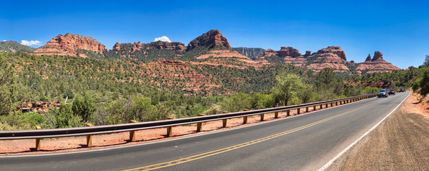
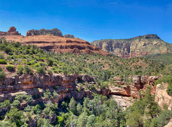
We also drove an hour south of Flagstaff to visit Sedona. We'd been there before, but it's always amazing seeing the red rocks surrounding town. We hiked up on Bell Rock, an iconic formation south of town.


We then moved on to eastern Arizona, where we camped for three nights in the town of Holbrook. One of its claims to fame is as the home of the Wigwam Motel (pictured below).

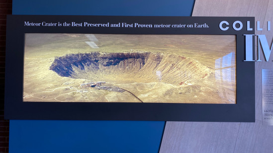
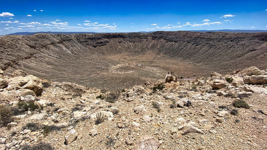
On the way to Holbrook, we stopped at Meteor Crater, created by a 150-foot-wide meteor impact about 10,000 years ago. It's privately owned by the Barringer family, whose patriarch worked for years to convince the world that the crater was formed by a meteor, rather than a volcano. You can hike part of the rim, and there is an interesting museum about the crater and about meteors in general. As you approach, you can see the outer rim sticking up from the flat countryside. As you get closer, there are signs marking off the miles that say "Prepare for Impact: 3 Miles," "Prepare for Impact: 2 Miles," etc. Of course Jeannette just had to experience the impact for herself.


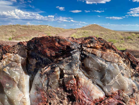
Holbrook is also a gateway town for Petrified Forest National Park. We'd visited there for a day when we first traveled west from Virginia in April 2019, but decided to return and explore some other portions of the park and trails we'd had to give short shrift to back then.
Petrified logs were formed 225 millions years ago (at the beginning of the age of dinosaurs) when giant conifers were knocked down, washed downstream, buried in layers of ash, and then fossilized, transforming over time into quartz and other minerals. Upper layers of harder rock were worn away over eons, exposing the ash layers which, like other "badlands" formations, erode away from wind and rain, gradually exposing the logs. Many have already been exposed, but others are still buried or partially exposed. It is amazing to see hundreds of trees or tree fragments littering a field.


On one trail, we visited the ruins of Native American dwellings built from petrified stone 800 years ago.

The levels of preservation in these logs are incredible. You can easily differentiate the bark layers from internal layers of the trees.

We also hiked in the Blue Mesa area of the park, with multi-banded ash layers and tailings of petrified wood that have fallen out of the canyon sides.


Finally, at the northern end of the national park, there are stunning views of the aptly-named Painted Desert.

We continued our route east to Albuquerque, where we spent five days. Albuquerque is only about an hour south of Santa Fe (where we'd stayed for a month), but was not an area that we'd explored much during our Santa Fe stay.
A note about Arizona and New Mexico: we found that the attitude about coronavirus in Arizona was largely "Covi-what?" People did not seem to take the virus seriously. Few people wore masks, and there was not much social distancing going on in the campgrounds where we stayed (although we made sure we were socially distant from others). The state had been one of the first to reopen, and as of this writing the case rate is climbing precipitously. Frankly, it made us nervous to spend any more time there.

In New Mexico, by contrast, the governor had really pushed to "flatten the curve," and most people wore masks whenever out and were clearly taking COVID very seriously. We were happy to be back in the state.

We took advantage of being in a big city to have some repair work done on the Ciaowagen. We went to a truck repair place to have our gearshift indicator repaired - it had slipped so that it read "Reverse" when we were in "Park," "Drive" when we were in "Reverse," etc. We'd also had a situation where the engine access cover had come loose a couple of months ago, and we'd just had it attached to the front of the RV with zip ties. We found a body shop in Albuquerque that was able to glue the brackets that hold the cover back onto the fiberglass of the RV.

We also experienced a true slice of Americana when we traveled on New Mexico's "Singing Road," a portion of historic Route 66 just east of Albuquerque that plays "America the Beautiful" if you drive on it at exactly 45 miles per hour. Click on the video below. Make sure sound is on and the volume is turned up. You should be able to hear the song playing underneath the car noise.
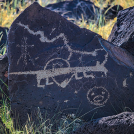
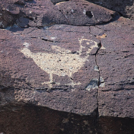
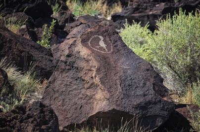
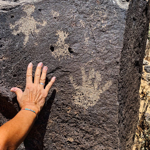
We visited Petroglyph National Monument, which preserves almost 1,000 Native American rock carvings at three separate sites in the Albuquerque area. West of the city, there are volcanic escarpments that end in piles of basalt boulders. Native Americans had removed outer rock layers from the boulders, exposing lighter inner layers, to create figures.

Most the petroglyphs were at least 500 to 800 years old. The meaning of many of the symbols are unknown.


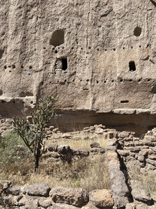
Another day we drove north to see Bandelier National Monument, which is west of Los Alamos. It had been closed when we were in Santa Fe and had just recently reopened. We'd visited it during our initial trip west in April 2019, but thought it would be nice to go back. Bandelier is set in a dramatic canyon carved out of volcanic tuff deposited 1,000 feet thick by a massive supervolcano eruption one million years ago.

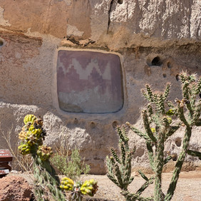
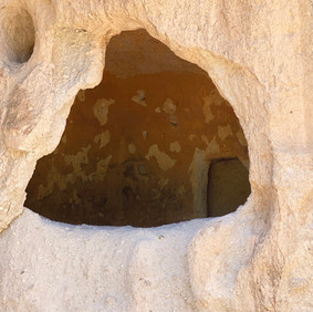
Some of the ruins were not accessible to us because the Park Service was repaving the hiking trail. However, we were able to hike to see areas where the Ancestral Puebloans had built dwellings into the natural caves that formed in the tuff cliffs. "Ancestral Puebloans" is now the preferred term for what we used to refer to as "Anasazi," until it became better understood that the word Anasazi actually translates to "enemy ancestors" in the Navajo language. The lines of drilled holes near the entrances to the caves were used to support wooden platforms - the first "boardwalk" in North America.


Another day we drove back up to the top of Sandia Peak, where we hiked a circuit trail that included some beautiful forest as well as the the ridge line overlooking Albuquerque.


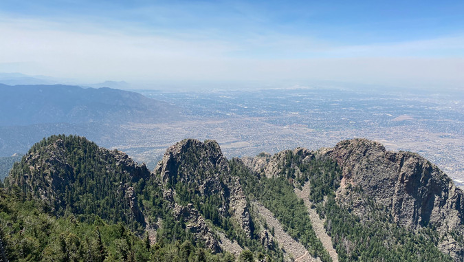
Forest fires burning outside Phoenix and Tucson made the air much less clear compared to our visit to Sandia Peak several weeks earlier (see comparison picture below).

On our last day, we visited the ABQ BioPark near Old Town Albuquerque. The zoo and aquarium were still closed, but we were able to take a walk using a prescribed one-way route through the beautiful botanical gardens there.


After spending three full months in Arizona and New Mexico, we thought it was about time to notch some other states onto our belts, so we headed up to Colorado for a month or more traveling throughout the Rockies.


Commentaires