
Visiting Re-Opened Parks, Part 2
- dougsmith51
- Oct 8, 2020
- 6 min read
Our last blog entry covered some of the southwestern parks and monuments we visited on our circuitous back to the East Coast. This entry completes our journey through the southwest. Many of the parks and monuments have restrictions (e.g., visitor center closed, no ranger programs, masks required), but at least they have reopened after being closed for months in the spring and summer due to COVID-19.
We stayed in the small tourist town of White's City, New Mexico so we could visit both Carlsbad Caverns National Park in New Mexico and Guadalupe Mountains National Parkh in Texas. The parks are only about 30 miles from each other, and both occupy parts of an ancient coral reef that existed millions of years ago on the edge of an inland sea. In the case of Carlsbad Caverns, after the reef was buried deep underground, oil and gas deposits gave off sulfur that mixed with ground water (forming sulfuric acid), dissolving the limestone and creating the caverns. After that area was uplifted later, the water drained away. Then, rainwater percolating through the ground mixed with the limestone to form carbonic acid, which dripped from the ceilings of the cave to form stalactites and onto the floor to form stalagmites, as well as other formations such as flowstone, drapery, columns, cave popcorn, etc.
Due to COVID, the park was restricting the number of visitors, and you had to get a timed entry pass, which were given out on a first-come, first-served basis. This time of year, there were not going to be issues with getting a pass, and we settled on an entry time of 1:00 pm (the last entries are at 1:45) to avoid crowds. Things went "downhill" from there and we ended up spending almost four hours underground.
The "natural entrance" to the cave drops 800 feet vertically before it begins to level out. In the 1920s, paying guests climbed down crude wire and wood ladders to pick their way over rocks with kerosene lamps, led by a cowboy turned cave explorer. Today a mile long, steeply winding paved walkway, built in the 1930s by the Civilian Conservation Corps, takes visitors into the cave. To exit, you take an elevator which rises 75 stories back to the surface.

After a bit of walking, the path takes a turn and sunlight is no longer visible, even indirectly. There were interesting formations on the way down such as the "whale's mouth."


After a mile's downhill hike, you enter what the park refers to as the Big Room. It's a large chamber the size of 27 football fields and almost a quarter-mile across, and the trail through and around it is a mile-and-a-quarter long. Carlsbad Caverns is not the largest cave in the world (and the Big Room is not the biggest chamber in the world), nor is it the longest, but we have to say it is one of the most beautiful, full of the decorations one imagines in a cave. Within the past couple of years, the inside lights have all been replaced with LEDs, and the Park Service worked with a cinematic lighting designer to decide what to illuminate and how, while still having the cavern feel like... a dark cave. Although it is dimly lit inside, we were able to take advantage of "night mode" on Doug's iPhone to get clear pictures without flash. We've pasted them in below for your viewing pleasure.


After our leisurely tour through the cavern, we waited till sunset to watch the bats who live within the cave come out for their nightly hunting. Some evenings thousands of bats fly out in formation. Unfortunately, we only saw, perhaps, a couple of hundred. At this time of year, many bats have begun to migrate south, so fewer bats remain to go out on nightly feeding runs.
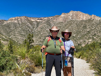
The next day we spent at Guadalupe Mountains National Park (GMNP). The mountains of the park are a continuation of the same ancient Permian reef that contains Carlsbad Caverns, and you can see a continuous line that almost looks like an extended mesa as you drive south from White's City. GMNP contains the four highest peaks in Texas, including Guadalupe Peak and El Capitan, seen in the photo below.

GMNP is quite remote, and there are no roads through the park at all. We took one very nice hike into McKittrick Canyon to the site of Pratt Lodge, which is normally open as a historic site but closed during COVID times. We had to cross McKittrick Creek a couple of times, and were rewarded with the beginnings of fall color, great mountain views, and rocking chairs on the lodge porch where we ate our lunch in comfort and style.


We continued on to the last southwest park we would visit: Big Bend National Park (BBNP) in Texas. It's right along the Mexican border and the Rio Grande River. Big Bend is a huge park - 1,200 square miles - and we spent three days exploring different parts of the park, indicated by the arrows on the map below. The river flows from left to right on this map, emerging from the Santa Elena Canyon, flowing along cliffs and flats as it takes its "big bend" at the bottom of the park, and then into Boquillos Canyon as it continues its flow to the Gulf of Mexico.

The first day we visited the Rio Grande Village area (orange arrow). All the services (visitor center, campground, store) were closed by COVID. We were able to see the river meandering through flat countryside.

There is a town called Boquillos in Mexico where, during normal times, BBNP visitors are ferried across the river in small boats to visit the cafes and shops in the village. However, the border has been officially closed by COVID, and Boquillos (which is more than 100 miles from the closest Mexican town) has been hard hit.
While we were hiking around, we saw a number of "pop-up shops" along the BBNP trails, and locals taking canoes across the Rio Grande to check their stock and collect payments left in cans and plastic jugs. Note the "No Wall" editorializing on some of the hiking sticks left for sale.


We also hiked to the spot were the river enters the high walls of Boquillos Canyon. In this picture, the U.S. is on the left bank, and Mexico is on the right.

The next day, we traveled to the opposite side of the park (purple arrow on the map) to visit Santa Elena Canyon. As you approach, you can see how the river has cut through an otherwise solid wall of cliffs.

There is a hike about 1/2 mile into the canyon, but to get there you need to ford a creek and scramble up a muddy bank on the other side.

We opted to stay on our side of the creek and enjoy the view of the Rio Grande exiting from the canyon (Mexico is on the left, the U.S. on the right).

Driving back from Santa Elena Canyon, we drove the Ross Maxwell Scenic Drive (Maxwell was an early park superintendent and a geologist). This area was once dominated by volcanos, and you could see many layers in the rock from different eruptions and flows).

There were also eroded volcanic formations such as the Mules Ears.

We hiked along a creek wash to see the Burro Mesa "pour-off", a seasonal waterfall dropping more than 100 feet. You can see how the occasional floods over the millennia have created a polished chute.


As we hiked, we could see colorful canyons and also our destination for our third day, the Chisos Mountains.


The Chisos Mountain Basin (green arrow on the map) was formed by volcanic eruptions, and over time the center of the mountains have eroded away, forming a basin. The debris has washed away over time through a feature called The Window (the notch in the picture below).

While in the mountains, we took a very nice hike partway up the Lost Mine Trail to a lookout where we would see a [somewhat hazy] view east to the desert plain and the mountains of Mexico.


BBNP is a place we would definitely return to explore more fully in the future.
It was time to book east big time, and we left the next morning for some full-day drives through Texas and Louisiana.


Wow! This is an amazing country of ours. You two will qualify as geologists in the next part of retirement! It is the wonders of geology and the perpetual nature of the ocean that give me a perspective for the future.
And, you'll have to give us all a photography lesson when you get home!